Jano
| Jano | |
|---|---|
| Municipality | |
 Jano | |
| Coordinates: 15°03′N 86°30′W / 15.050°N 86.500°WCoordinates: 15°03′N 86°30′W / 15.050°N 86.500°W | |
| Country |
|
| Department | Olancho |
| Villages | 8 |
| Area | |
| • Total | 362.71 km2 (140.04 sq mi) |
| Population (2015) | |
| • Total | 4,805 |
| • Density | 13/km2 (34/sq mi) |
Jano is a town and municipality in the north west of the Honduran department of Olancho, west of Guata, south of Esquipulas del Norte and north of Manto.
Villages
Jano municipality encompasses the following villages:[1]
- Jano
- Comayaguela
- El Zapotillo
- La Pita
- La Victoria
- Las Labranzas
- Pacaya
- Pintora
References
- ↑ Instituto Nacional de Estadísticas, Honduras. (Censo 2001)
Capital: Juticalpa | ||
| Municipalities | 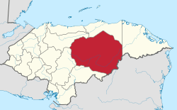 | |
This article is issued from
Wikipedia.
The text is licensed under Creative Commons - Attribution - Sharealike.
Additional terms may apply for the media files.