San Francisco de Becerra
| San Francisco de Becerra | |
|---|---|
| Municipality | |
 San Francisco de Becerra | |
| Coordinates: 14°38′N 86°06′W / 14.633°N 86.100°WCoordinates: 14°38′N 86°06′W / 14.633°N 86.100°W | |
| Country |
|
| Department | Olancho |
| Villages | 7 |
| Area | |
| • Total | 332.92 km2 (128.54 sq mi) |
| Elevation | 407 m (1,335 ft) |
| Population (2015) | |
| • Total | 9,878 |
| • Density | 30/km2 (77/sq mi) |
San Francisco de Becerra (Spanish pronunciation: [sam fɾanˈsisko ðe βeˈsera]) is a municipality in the interior of the Honduran department of Olancho, slightly to the south. It is boredered by Juticalpa in the west and Catacamas in the east.
Sports
Local football club Alianza de Becerra play in the Honduran second division.
Capital: Juticalpa | ||
| Municipalities | 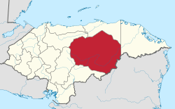 | |
This article is issued from
Wikipedia.
The text is licensed under Creative Commons - Attribution - Sharealike.
Additional terms may apply for the media files.