Jakhal
| Jakhal | |
|---|---|
| village | |
 Jakhal Burj (Fort) | |
 Jakhal Location in Rajasthan, India  Jakhal Jakhal (India) | |
| Coordinates: 27°55′N 75°26′E / 27.91°N 75.44°ECoordinates: 27°55′N 75°26′E / 27.91°N 75.44°E | |
| Country |
|
| State | Rajasthan |
| District | Jhunjhunu |
| Elevation | 375 m (1,230 ft) |
| Population (2011) | |
| • Total | 7,493[1] |
| Languages | |
| • Official | Hindi |
| Time zone | UTC+5:30 (IST) |
| PIN | 333305 |
| Telephone code | 01594 |
| ISO 3166 code | RJ-IN |
Jakhal is a village in the Shekhawati region of Rajasthan, India. It is located in the district of Jhunjhunu, approximately 20 km east of Nawalgarh and 30 km south of Jhunjhunu. Jakhal was founded by Salehadi Singh Shekhawat on 9 August 1732 (teej of Sravana Shukla 1789). Hundreds of its residents serve in Indian Army. However, the farming is the main occupation for the most of Jakhal residents. The main crops in the monsoon seasons are Bajara (Pearl Millet), Moth, and Guar. The main crops in the winter months are Wheat, Barley, Sarson (Mustard oil, Mustard seed), and Chana (Chickpeas).
History
1732 AD Founder: Thakur Salehadi Singh
Jakhal was founded by Thakur Salehadi Singh Shekhawat on 9 August 1732 (Teej of Sravana Shukla 1789). Salehadi Singh was the younger brother of Thakur Shardul Singh (ruler of Jhunjhunu). He was also the commander of his brother's army. He fought several wars on the behalf of his brother. However, he has to stay in Jakhal before attacking Bhorki. He was kind of impressed with the natural beauty of the area and decided to conquer the area from the local warlord. The warlord decided to keep quiet because he knew the stories about Salehadi Singh's bravery.
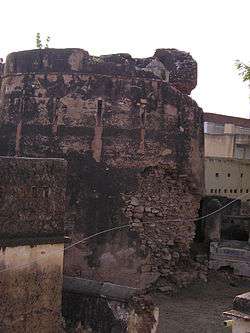
Jakhal Fort
In 1735, Salehadi Singh built a bastion (burj) in Jakhal. It is believed that Sikar's king Laxaman Singh destroyed parts of this burj in a cannon attack. The remains of this burj is still there (see photo right). Salehadi Singh's four sons – Samarth Singh, Sangraam Singh, Shev Singh, and Gulab Singh – decided to stay in Jakhal and their descendants still live in Jakhal in "Chaar Paana".
Geography
Jakhal is located at 27°55′N 75°26′E / 27.91°N 75.44°E. It has an average elevation of 375 metres (1230 feet).
Climate
Jakhal is located in the semi-desert area of the Thar Desert, the surrounding area is predominantly covered with sand dunes.
Neighborhoods
To the north of Jakhal is Bugala, Ajari, Baragaon, Jhunjhunu, Udawas. To the east of Jakhal is Sonthali, Titanwar, Gudha Gorji ka,. To the south is Bhorki, Inderpura, Udaipur Shekhawati, Dhamora. To the west is Kari, Barwasi, Nawalgarh, Mukundgarh, Sikar, Dundlod.
People
According to 2011 census, Jakhal had a population of 7,493, of which 3,852 were male and 3,641 female. There were 1,088 children 0-6 and the literacy rate was 62.95% (70.63% for males and 54.98% for females). 3,744 people (50%) were from scheduled castes.[1]
References
- 1 2 "Jakhal Populatiom". Census 2011. Retrieved 30 March 2018.