Jagal (village)
| jagal جاگل | |
|---|---|
| Village | |
| Coordinates: 32°51′05″N 74°04′20″E / 32.85139°N 74.07222°E | |
| Country | Pakistan |
| Province | Punjab |
| Region/Division | Gujranwala |
| District | Gujrat District |
| Tehsil | Kharian |
| Union Council | Dilawar-Pur |
| Time zone | UTC+5 (PST) |
| Postal Code | 50991 |
| Area code(s) | 053 |
Jagal (Urdu: جاگل) is a village in District Gujrat Punjab, Pakistan, situated about 6 kilometres (4 mi) east of Kotla Arab Ali Khan. The village is 38 kilometres (24 mi) from Gujrat city and about 30 kilometres (19 mi) from Kharian city. The union council of Jagal is Dilawarpur which is 2 kilometres (1 mi) to the east. The border of Azad Kashmir lies approximately 10 kilometres (6.2 mi) north of the village.
Picture gallery
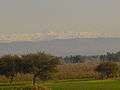 view from Jagal
 hills View
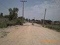 Road under construction
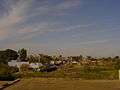 Jagal view
| Wikimedia Commons has media related to Jagal (village). |
Coordinates: 32°49′45″N 74°08′04″E / 32.82917°N 74.13444°E
This article is issued from
Wikipedia.
The text is licensed under Creative Commons - Attribution - Sharealike.
Additional terms may apply for the media files.