Jaega
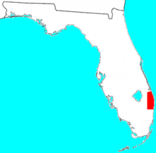
The Jaega (also Jega, Xega, Jaece, Geiga) were Native Americans living in a chiefdom of the same name, which included the coastal parts of present-day Martin County and Palm Beach County, Florida at the time of initial European contact, and until the 18th century. The area occupied by the Jaega corresponds to the East Okeechobee Area, an archaeological culture that is part of, or closely related to, the Belle Glade culture.
History
The East Okeechobee Area has received relatively little attention from archaeologists, and little is known of the origins of the Jaega. The earliest mention of the Jaega came from Hernando de Escalante Fontaneda, who was held captive by indigenous peoples in Florida for 17 years until 1665 or 1666. He relates that the Jaega, along with the Ais and the obscure Guacata, salvaged precious metals and other goods from ships that wrecked along the Florida coast.[1] Escalante Fontaneda also implied that the Jaega spoke the same language as the Ais, who lived along the Indian River Lagoon to the north of the Jaega.[2][3] The Jaega may have been related to the Ais people, who occupied the coast to their north. (The Ais language has been linked to the Chitimacha language by linguist Julian Granberry.[4]) The Jaega were linked to the Ais by marriage between chiefs and their relatives.[5]
In 1665, the Spanish built the Presidio of Santa Lucia at what is probably the present-day St. Lucie River. Some of the Spanish records indicate that the presidio was located in Jaega territory. The Jaega were initially friendly towards the Spanish, but later attacked the presidio and forced the Spanish to withdraw less than a year later.[6]
Culture
There is little written history about the Jaega. They were likely similar in culture and custom to the surrounding Calusa, Tekesta and Ais tribes. The indigenous peoples of South Florida were all hunter-gatherers. Food was abundant enough to make agriculture unnecessary. Middens (Refuse mounds), consisting mostly of oyster and conch shells, also contain clues to the Jaega culture. Their diet consisted mainly of fish, shellfish, sea turtles, deer and raccoon, as well as wild plants including coco palms, sea grapes, palmetto berries and tubers.[7] Bits of broken pots and scraps of grass skirts demonstrate that crafts including pottery and weaving were known and practiced. One of the largest and best preserved Jaega middens is within what is now DuBois Park at the Jupiter Inlet Historic and Archeological Site, across from the Jupiter Inlet Lighthouse.[7]
Although there are no deposits of flint in South Florida, flint dart points have been found at Jaega sites, indicating trade with northern tribes.[7] The people used wood, bone and shell to craft tools and weapons.
Spanish reports describe elaborate ceremonies involving an elite class of priests, hundreds of singers and dancers, and complex ritual practice.[8]
Early encounters with the Spanish
The Journal of Jonathan Dickinson, who was part of a shipwrecked party detained by the Jaega of Jobe for several days in 1696, contains descriptions of the Jaega of the town of Jobe (near present-day Jupiter Inlet). He wrote that Jobe was subject to the Ais chief who resided in Jece (near present-day Vero Beach).[9] In the later part of the 16th century, Spanish soldiers who had been driven out of Ais territory built a fort called St. Lucie at the Jupiter Inlet. They soon abandoned it after relations with the Jaega turned sour.[10][11]
The geographic name "Hobe Sound" is derived from the name of the Jaega village. The Spanish pronounced the name "Ho-bay," which has evolved into the current anglicized "Hobe" (which is pronounced like "robe").[12]
Early territorial map
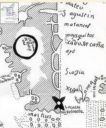
The partial map shown on the right is originally titled as Planta de la costa de la Florida'y en que paraje La Laguna de Ma'ymi'y adonde se ha de hacer un fuerte (Map of the coast of La Florida and in which spot the Lake of Maimi and to where we have to make a fort) dated circa 1600. The original can be found in the Archives of the Indies in Sevilla, Spain, identified as Maps de Mexico y Florida collection of Pedro Torre Lanzas, the original cartographer is unknown. A reproduction of this map is in the Library of Congress.[13]
It shows the relative locations of Saint Augustine (S Agustin), Cape Canaveral (Cabo de Cañabezal), as well as the approximate territories of the Ays (Ais) and Xega tribes.
Laguna de Meiymi is shown as the name of the lake now known as Lake Okeechobee. This is the first known map reference to Miami.[13] Other alternate spellings in early Spanish sources include Maimi, Mayma and Meiymi (see also Mayaimi).[13] The large black X apparently marks a fresh water spring; it corresponds to the site of the City of Miami.
Notes
- ↑ Wheeler and Pepe 2002, p. 234.
- ↑ Hann 2003, p. 62.
- ↑ Austin 1997, p. 2.
- ↑ Granberry, Julian (2011). The Calusa: Linguistic and Cultural Relationships. Tuscaloosa, Alabama: The University of Alabama Press. p. 47. ISBN 978-0-8173-1751-5.
- ↑ Brech:125
- ↑ Wheeler and Pepe 2002, p. 224, 233.
- 1 2 3 Early Tribes: Jaega and Jobe, Palm Beach County History Online
- ↑ Jonathan W. Koontz, Lake Worth: Jewel of the Gold Coast, Lake Worth Chamber of Commerce, 1997, pp. 41-46.
- ↑ Dickinson:34, 38
- ↑ Hann:78
- ↑ Jonathan Dickinson placed the Ais town he called Santa Lucea (St. Lucie) two days' travel north of the Jupiter Inlet:16, 24
- ↑ "Hobe Sound History". hobesound.org. The Hobe Sound Chamber of Commerce, Inc. Archived from the original on February 7, 2008. Retrieved October 10, 2018.
- 1 2 3 Old Florida Maps
References
- Austin, Daniel W. (Summer–Fall 1997). "The Glades Indians and the Plants they Used. Ethnobotany of an Extinct Culture" (PDF). The Palmetto. 17 (2): 7–11.
- Brech, Alan (2004). Neither Ocean nor Continent: Correlating the Archeology and Geomorphology of the Barrier Islands of East Central Florida. Unpublished thesis, University of Florida. Found at - accessed November 27, 2005
- Carr, Robert S. (2012). Ashley, Keith; White, Nancy Marie, eds. Mississippian Influence in the Glades, Belle Glade and East Okeechobee Area of South Florida. Late Prehistoric Florida: Archaeology at the Edge of the Mississippian World. Gainesville, Florida: University Press of Florida. pp. 62–80. ISBN 978-0-8130-4014-1.
- Dickinson, Jonathan (1700). 2nd Ed. God's protecting providence, man's surest help and defence, in times of the greatest difficulty, and most eminent danger. Evidenced in the remarkable deliverance of Robert Barrow, with divers other persons, from the devouring waves of the sea; amongst which they suffered shipwrack: and also, from the cruel, devouring jaws of the inhumane canibals of Florida. London. On-line at American Libraries (Internet Archive) . URL retrieved 24 March 2010.
- Hann, John H. (2003). Indians of Central and South Florida: 1513-1763. Gainesville, Florida: University Press of Florida. ISBN 0-8130-2645-8.
- Wheeler, Ryan J.; Pepe, James P. (September–December 2002). "The Jobé and Jaega of the Palm Beach County Area". The Florida Anthropologist. 55 (3–4): 221–241 – via University of Florida Digital Collections.