Jadrija
| Jadrija | |
|---|---|
| Village | |
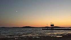 Sunset on Jadrija beach | |
 Old map Sebenico by Martin Rota | |
 Jadrija Old map Sebenico by Martin Rota | |
| Coordinates: 43°43′33″N 15°50′35″E / 43.72583°N 15.84306°E | |
| Country |
|
| Region | Dalmatia |
| County | Šibenik-Knin County |
| Time zone | UTC+1 (CET) |
| • Summer (DST) | UTC+2 (CEST) |
| Website |
jadrija |
Jadrija, officially a part of Šibenik[1], is a popular seaside resort located on a man made peninsula at the entrance of the St. Anthony Channel leading to Šibenik, Croatia. The only road used to get there is the ![]()
Jadrija was logged into the registry of protected Croatian cultural heritage architectural sites.[2]
It got its name from the island of Saint Andreas (Sveti Andrija) that was connected in 1922 to the mainland by man. It is a first official beach for the town of Šibenik with a history of over 90 years.[3] The idea for the city beach came from Šime Grubišić-Rovilo, the first tour guide in Šibenik[4], while the local pine forest was planted by another local Ante Frua, known for his long lasting work on planting forests in Šibenik area[5].
At the end of the peninsula a lighthouse of St. Andrea was built in 1871 by Austrian-Hungarian Empire.[6] The lighthouse stands opposite to the fortress of St. Nicholas Fortress at the other side of the Saint Anthony channel built during 1535-1550.[7]Jadrija is one of the best places in Croatia to wind surf. Many locals have their summerhouses here. Nearby places to Jadrija are Vodice and Srima Number of nearby islands (Zlarin, Prvić, Žirje and Kaprije) are ideal for day trips going by public boat from Šibenik.
Closest national park is Krka National Park.
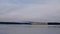 View of St. Nicholas Fortress from Jadrija
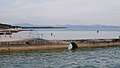 Gulls on Jadrija
.jpg)
.jpg)
.jpg)
.jpg)
References
- ↑ "Četvrti i mjesni odbori". www.sibenik.hr. Retrieved 2018-03-21.
- ↑ http://www.min-kulture.hr/default.aspx?id=6212&kdId=210092239
- ↑ http://www.jadrija.net/
- ↑ "Jadrija | Vodiči na Putovnica.net". Putovnica.net (in Croatian). Retrieved 2018-03-21.
- ↑ User, Super. "Jadrija". www.sibenikregion.com (in Croatian). Retrieved 2018-03-21.
- ↑ http://bib.irb.hr/prikazi-rad?lang=en&rad=261351
- ↑ https://books.google.hr/books?id=Qho7AQAAIAAJ&num=19
Coordinates: 43°43′33.11″N 15°50′35.86″E / 43.7258639°N 15.8432944°E