Iwaya Dam
| Iwaya Dam | |
|---|---|
 | |
| Official name | 岩屋ダム |
| Location | Gero, Gifu Prefecture, Japan. |
| Coordinates | 35°45′39.8″N 137°09′25.8″E / 35.761056°N 137.157167°ECoordinates: 35°45′39.8″N 137°09′25.8″E / 35.761056°N 137.157167°E |
| Construction began | 1966 |
| Opening date | 1976 |
| Dam and spillways | |
| Impounds | Maze River |
| Height | 127.5 meters |
| Length | 366.0 meters |
| Reservoir | |
| Total capacity | 173,500,000 m³ |
| Catchment area | 1,734.9 km² |
| Surface area | 424 hectares |
| Power Station | |
| Installed capacity | 28.8 MW |
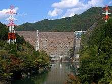
The Iwaya Dam (Iwaya Damu) is a dam in the city of Gero,Gifu Prefecture, Japan on the Maze River, part of the Kiso River system. The dam is a rockfill dam with a height of 127 meters and was constructed as a multipurpose dam for flood control, supply of municipal and industrial water, irrigation water and hydroelectric power generation. The reservoir created by the dam supplies the Chubu Electric Power Company's Mazegawa No.1 Power plant with a capacity of 288 MW hydroelectric power station.[1]
References
- ↑ "Hydropower & Dams in South and East Asia" (PDF). Hydropower and Dams. p. 9. Retrieved 3 October 2010.
| Wikimedia Commons has media related to Iwaya Dam. |
This article is issued from
Wikipedia.
The text is licensed under Creative Commons - Attribution - Sharealike.
Additional terms may apply for the media files.