Iwamuro Station
Iwamuro Station 岩室駅 | |
|---|---|
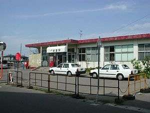 Iwamuro Station in July 2004 | |
| Location |
1-14-1 Wanō, Nishikan-ku, Niigata-shi, Niigata-ken 953-0125 Japan |
| Operated by |
|
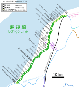
| Line(s) | ■ Echigo Line |
| Distance | 53.8 km from Kashiwazaki |
| Platforms | 1 side platform |
| Tracks | 1 |
| Other information | |
| Website |
www |
| History | |
| Opened | 25 August 1912 |
| Previous names | Wanō (until 1965) |
| Traffic | |
| Passengers (FY2010) | 545 daily |
| Location | |
 Iwamuro Station Location within JR Echigo Line  Iwamuro Station Iwamuro Station (Japan) | |
Iwamuro Station (岩室駅 Iwamuro-eki) is a railway station located in the Iwamuro neighbourhood of Nishikan-ku, Niigata, Japan. It is operated by JR East.
Lines
Iwamuro Station is served by the Echigo Line, and is 53.8 kilometers from the starting point of the line at Kashiwazaki Station.
Layout
The station consists of one ground-level side platform serving a bi-directional track. The station building has a waiting hall and toilets. Outside there are taxis and regular bus services.
The station is unattended. Suica farecard can be used at this station.[1]
Adjacent stations
| « | Service | » | ||
|---|---|---|---|---|
| Echigo Line | ||||
| Kita-Yoshida | - | Maki | ||
History
When the station opened on 25 August 1912 on the Hakusan Echigo Railway it was originally called Wanō Station (和納駅). It had a manned station office, four platforms, sidings and freight yards. On 1 October 1927, the Echigo line was nationalised. The station was renamed Iwamuro on December 25, 1965. On January 1, 1973 all freight handling ceased at the station. The sidings and two side platforms were closed and eventually removed. On 1 April 1987 the station was transferred to JR East Japan Railways when the Japanese rail network was privatized. Beginning on 21 January 2006, passengers were able to use Suica cards at the station. On 31 March 2007, after 95 years, the manned station office was closed. Tickets are now purchased from an automated vending machine.
Surrounding area
- Japan National Route 116
- Wanō Elementary School
- Wanō Post Office
See also
References
- ↑ Suica>利用可能エリア>新潟エリア>拡大図 [Suica Area in Niigata] (in Japanese). Japan: JR East. Retrieved 17 November 2017.
External links
- JR (East) Railway (Japanese)
- Video:Maki to Iwamuro
Coordinates: 37°43′16.73″N 138°52′47.74″E / 37.7213139°N 138.8799278°E