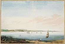
Ilha de Itamaracá
.png)

Ilha de Itamaracá is an island and municipality in Pernambuco, Brazil on the Atlantic Ocean. Itamaracá means "stone shaker" in Tupi, from the words itá ("stone")[1] and mbara'ká ("shaker").[2] It is separated from the mainland by the Canal de Santa Cruz, a salt water channel both mouths of which are on the Atlantic Ocean.
Itamaracá has a total area of 66.68 square kilometres (25.75 sq mi) and had an estimated population of 24,413 inhabitants in 2014 according to IBGE.[3] It is located in the metropolitan area of Recife, the capital city of Pernambuco state. The main activities of the population are fishing and tourism. Recife is located about 38 kilometres (24 mi) to the south whereas Olinda, another important town of Pernambuco and also UNESCO World Heritage, is 30 kilometres (19 mi) to the south. It was awarded city status on 1 January 1959.[4]
Geography
- State - Pernambuco
- Region - RMR (Recife)
- Boundaries - Goiana (N), Igarassu (S), Itapissuma (W), Atlantic ocean (E)
- Area - 66.68 square kilometres (25.75 sq mi)
- Elevation - 3 metres (9.8 ft)
- Hydrography - Small coast rivers
- Vegetation - Atlantic forest,capoeira,capoeirinha, coconut trees and mangrove
- Clima - Hot tropical and dry
- Annual average temperature - 25.3 c
- Main road - BR 101 and PE 041
- Distance to Recife - 38 km
History
In the early 1500s before Portuguese colonization, the island was the site of a trading post for furs and other native goods, and transhipment depot for Brazilwood. In 1516, was founded the first sugar cane mill in Portuguese America - the oldest still-inhabited, Portuguese settlement in America. The island at that time was occupied by various loosely related tribes of Tupi-Guarani native South American peoples. Later, the island became part of the Captaincy of Itamaracá (most of which today is occupied by the state of Paraiba) which took its name from the island, established by King John III of Portugal in 1534. The chief economic activity in the following century and a half was sugar cane processing, in engenhos (sugar mills). While Itamaracá was administratively separate, it operated as a political and economic subdivision of Pernambuco. With the rise of the gold economy in the late 17th century, Itamaracá became economically isolated.
Itamaracá is renowned for having one of the first, if not the first, Jewish community in the Americas. In the Yosef Goldman Collection, there is a book titled Sefer Shefa Tal, a kabbalistic volume that was printed in Hanau, Germany, in 1612. It contains a handwritten statement of ownership by Rabbi Jacob Lagarto of a congregation in Tamarica, Brazil. Rabbi Lagarto came to Brazil as a young man and was the author of a volume of aphorisms (copies of which, evidently, no longer exist). The book is the only known physical link to this Jewish community, since there are no other known artifacts from it.[5][6]
Tourist attractions
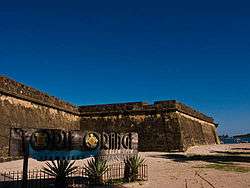
- Forte Orange, first built by the Dutch in 1631 and rebuilt by the Portuguese in 1654 * Vila Velha, seat of the former Itamaracá Hereditary Captaincy (Church of Our Lady of the Conception, colonial houses)
- Sao Joao and Amparo "engenhos" (historic sugar mill and plantation complexes)
- Ibama's centre of sea mammals (Trichechus manatus)
- Corao de Avião island
- Currais (devices for fishing)
- Snorkeling
- Vila Velha
- Lagoa Azul
- Nossa Senhora da Conceicao: Second oldest church in Brazil
- Folklore: famous for a musical style known as "ciranda," of which Lia de Itamaracá is the most well-known singer
Beaches
- Pontal da Ilha beach
Has calm waters, mangue vegetation, suitable for swimming. It is located in the intersection between Catuama River and Santa Cruz channel.
- Fortinho beach
Has weak waves, large rocks, and not depth waters.
- Pontal de Jaguaribe beach
Considered dangerous because of the estuary of Jaguaribe River. Also, shows area of advanced coastal erosion.
- Jaguaribe beach
Located in the urban area of the municipality, is two kilometers long and has several bars and restaurants. Every year, it holds a fishing festival of garfishes. Its major attraction is the Lady Lia, a well known singer of Ciranda, a folklore musical style. It has a small strip of land when at high tide. There lies the cross of Our Lady of Pilar.
- Quatro cantos beach
Its name means four corners. It's an urban beach and when at high tides, it just has small sand strip.
- Pilar beach
Urban beach with a small strip of land when at high tide. There is a cross of Our Lady of Pilar.
- Rio Âmbar beach
Has quiet waters and fine sands. Also has the Itamaraca Yacht club and numerous summer houses.
- Baixa Verde beach
Its name means low green. It's got clear sand, coconut trees vegetation, and summer and fishermen's houses.
- Forno de Cal beach
Area of occurrence of coastal erosion, has now containment dykes.
- Forte Orange beach
Fort Orange in English, has its name due to the presence of a Dutch fort built in 1631 and re-built by Portugueses in 1654. It is the site/point where boats and rafts cross the Jaguaribe River to the Coroa do Avião beach islet. Also, it has an Ibama center of sea mammals (Trichechus manatus) for their lives preservation and studies. It's got calm waters and many bars.
- Enseada dos Golfinhos beach
Its name means "dolphins bay". It has mangal vegetation and some sands banks. It's suitable for swimming. Unlike what the name suggests, there are no dolphins in this area. In Pernambuco, just Fernando de Noronha is visited by these animals.
- São Paulo beach
It has extensive sand banks, reefs and tide pools.
- Sossego beach
Its name means "tranquility". It has mangrove vegetation, sand banks and natural pools. The Jaguaribe River estuary flows there.
Economy
The main economic activities in Itamaraca are based in tourism, primary sector especially artisanal fishing and local commerce.
Economic indicators
| Population | GDP x(1000 R$).[7] | GDP pc (R$) | PE | RMR |
|---|---|---|---|---|
| 18.658 | 76.266 | 4.340 | 0.13% | 0.19% |
Economy by Sector 2006
| Primary sector | Secondary sector | Service sector |
|---|---|---|
| 6.35% | 14.84% | 78.81% |
Health indicators
| HDI (2000) | Hospitals (2012) | Hospitals beds (2007) | Children's Mortality every 1000 (2005) |
|---|---|---|---|
| 0.743 | 1 | 363 | 9.0 |
Penal Facilities
Itamaraca island has a judicial asylum, a maximum security prison and a semi-open facility.
Gallery
 Ilha de Itamaracá Beach
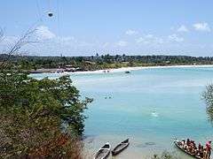 Ilha de Itamaracá estuary
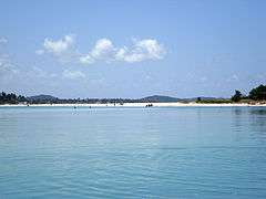 Estuary
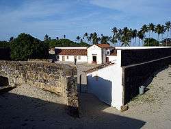 Fort Orange
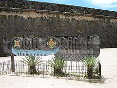 Forte Orange
See also
References
- ↑ Vocabulario Tupi
- ↑ FERREIRA, A. B. H. Novo Dicionário da Língua Portuguesa. Segunda edição. Rio de Janeiro: Nova Fronteira, 1986. p. 1087
- ↑ "Ilha de Itamaracá" (in Portuguese). Bras%lia, Brazil: Instituto Brasileiro de Geografia e Estatstica. 2015. Retrieved 2015-08-26.
- ↑ "História do Município | Prefeitura Municipal da Ilha de Itamaracá". Prefecture of the Ilha de Itamaracá (in Portuguese). Retrieved 20 September 2018.
- ↑ Levine, Yitzchok (6 December 2006). "Hooked On American Jewish History". jewishpress.com. The Jewish Press. Retrieved 2 April 2016.
- ↑ Oppenheim, Samuel (1909). "The Early History of the Jews in New York, 1654-1664: Some New Matter on the Subject". American Jewish Historical Society. Retrieved 2 April 2016.
- ↑ Itamaraca 2007 GDP IBGE page 30 Archived 2016-03-04 at the Wayback Machine.
- ↑ PE State site - City by city profile
External links
- Itamaracá island
- Sea mammals preservation project
- Lia (ciranda singer) show
- https://web.archive.org/web/20081120162036/http://www.jewishpress.com/page.do/20061/Hooked_On_American_Jewish_History.html
- https://books.google.com/books?id=jJEvn6AoYa8C&pg=PA45&lpg=PA45&dq=tamarica+brazil&source=web&ots=hei5iS_tHm&sig=w8rzVMYs1p0szVbkSsHWzSiG0-w