Isle of Doagh

The Isle of Doagh (also Doagh Isle) is a peninsula in the north west of Ireland, in County Donegal. It once was an island. Over time, the channel between Doagh and the mainland silted up and it became joined to the mainland.[1][2][3] Nevertheless, the area continued to be referred as the Isle of Doagh. The area comprises five townlands; Ballymacmoriarty, Carrickabraghy, Carrowreagh, Fegart and Lagacurry.[4]
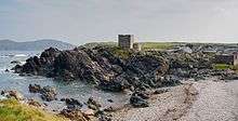
The ruins of Carrickabraghy Castle stands at the north-western extremity of the peninsula.[5]
History
Neolithic period
The Isle of Doagh has one of the largest clusters of rock art sites in Ireland. The markings are around 4000–5000 years old.[6]
Early Medieval Period
The Island was a stronghold of the Lords of Carraig Bhrachai who were part of the O Maolfabhail Sept (anglicized McFall). There are numerous references to the inhabitants of the Isle of Doagh, in particular Carrickabraghy, in the Annals of the Four Masters. The earliest historical reference of Carrickabraghy is in 834 when Niall Caille led an army into Leinster. The Annals refer to one of his officers, Fearghas, son of Badhbhchadh, who was Lord of Carraig Bhrachai. According to the annals, Fearghas was killed by Munster men during the campaign.
17th and 18th century
Several townlands within the Isle of Doagh are mentioned in the 1665 Hearth money rolls; a tax levied on chimneys whose revenues were used to support the Royal Household. A total of 18 households paid the tax from "Lagacurry, Fegurt, Carickbracky, Carowreagh, and Ballym'Murty", of which 11 households carried the name of "O'Dougherty".[7] In the 1654 Civil Survey, these townlands are also referred as the property of Arther Lord Chichester, Lord Viscont Carrickfergus.[8] The survey provided some limited information about economic activity in the area, which were the cultivation of oats, barley, wheat and rye. There was also some salmon and seal fishing.
19th Century
The coastline around the Isle of Doagh was notoriously hazardous for shipping and fishing. Throughout the 19th century, the surrounding seas witnessed a number of maritime accidents. On Wednesday, November 24, 1841, a schooner called the James Cook struck some rocks near Glashedy Island and broke up. The master and nine crew drowned.[9] On the morning of April 22, 1847, seven fishermen from the Isle of Doagh were drowned. In relatively calm weather, their boat capsized after it was hit by a sudden swell. At the time of the accident, the boat was crossing the Bay of Strabega. The names of the dead were Donald Doherty, owner of the boat, who left a wife and six children; Patrick Doherty, who left a wife and three children; James MacLoughlin, a wife and four children; Patrick (Roe) Doherty, a wife and one child; William Doherty, a young unmarried man; Hugh McCool, who was unmarried; John McLoughlin, a widow's son, and her only support. William Doherty, the eighth person on board, escaped by swimming ashore.[10] In March 1878, a large barque called the Danube ran aground on the Isle during a severe storm. It was sailing from Liverpool to New York. It lost its masts and began to drift aimlessly. Two coastguards from Malin put out in a small boat and reached the vessel. The rescue craft was hit by a huge wave, and one of the coastguards was drowned. Subsequently, a line was floated ashore by means of a barrel, and the crew, twelve in number, were hauled ashore safely.[11]
During the 19th century, the area was associated with the illegal production of Poitín. In April 1898, the Royal Irish Constabulary conducted a mass raid on homes on the Isle and found illegally distilled spirits in several locations.[12] Prosecutions of local inhabitants for illegal distillation were commonplace. For example, in August 1878, the home of a widow called Mary McGeoghegan, from Maheranoll, Isle of Doagh, was raided by the R.I.C. The constabulary found a jar containing one gallon and half of illicit spirits concealed in her potato garden at the rear of her house. Opposite her kitchen door, the constabulary found a still that had been used for illicit distillation. A month later, at the Malin Petty Sessions, she was fined £6.[13]
The Land League, which campaigned for agrarian reform, was active on the Isle. In 1880, John Mooney, a process-server was attacked by a large crowd while he was serving a writ for a debt. Mooney took refuge in the local school but was forced out and made to swear on his knees that he would never serve any writs again. Five local men were subsequently arrested and tried at Carndonagh Magistrates. However, the men were acquitted after Mooney, the school master and other witnesses refused to identify the men as assailants.[14]
Second World War
In February 1941, a mine washed up on a local beach. It was detonated by Irish Free State troops stationed at Fort Lenan. The explosion shook houses up to ten miles away.[15]
Carrickabraghy Castle
At the extreme westward point of the Isle of Doagh is Carrickabraghy Castle, which is sometimes known as "Doherty's Castle". The Castle stands on a large rock known as Friars Rock. The castle was constructed in the late 16th century and it was last inhabited in 1665. The structure of the castle included an oval bawn and towers seven circular towers. The bawn and towers enclosed a keep. To the south of the keep stood a small tower which is believed to have belonged to a church. The walls of the castle are 3 ft 9 inches wide.[16]
Doagh Famine Village
In Lagacurry, a collection of traditional Irish houses have been transformed into a folk museum. The museum illustrates community living from the mid-19th century times right up to the present day.[17]
Glashedy Island
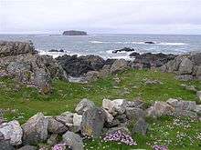
Glashedy Island (Irish: Glaiséidí) is a rock island approximately 3 kilometres (2 mi) west of the Isle of Doagh. It is currently uninhabited. Its former name until the early 19th century was Seale Island. At various times, the Island has been used to farm sheep. The 1654 Civil Survey indicates that the Island was also used as a base for seal fishing.[8]
Notable people
- Stephen McLaughlin (born 1990), footballer[18]
References
- ↑ Clark, Wallace (2003). Donegal Islands. Cottage Publications. p. 19. ISBN 978-1900935319. Retrieved 13 May 2016.
- ↑ Maghtochair (1867). Inishown: its histories, traditions and anquities. Londonderry. p. 6.
- ↑ Proceedings of the Royal Irish Academy. Dublin: Royal Irish Academy. 1877. p. 21.
- ↑ "Irish Townlands".
- ↑ Fraser, James (1844). A handbook for travellers in Ireland. Dublin: William Curry. p. 583. Retrieved 13 May 2016.
- ↑ Beattie, Sean (2017). "History of Donegal".
- ↑ "1665 Hearth Money Rolls". Clonmany. 2017.
- 1 2 "The Civil Survey 1654: County Donegal: Barony of Enishowen". Irish Manuscripts. 2017. Archived from the original on 2012-11-28.
- ↑ "Shipwreck and the loss of ten lives". Belfast Newsletter. 30 November 1841.
- ↑ "Ireland". Glasgow Herald. 26 April 1847.
- ↑ "Shipwreck on Donegal Coast". Belfast Telegraph. 9 March 1878.
- ↑ "Raid on Inishowen Smugglers". Londonderry Sentinel. 19 April 1898.
- ↑ "Malin Petty Sessions". Derry Journal. Retrieved 18 September 1874. Check date values in:
|access-date=(help) - ↑ "The operations of the Land League in Donegal". Belfast Newsletter. 22 November 1880. Retrieved 2017. Check date values in:
|access-date=(help) - ↑ Boatmen search for mine (February 14, 1941). "Irish Press". Archived from the original on 2013-11-08.
- ↑ Beattie, Sean (1994). Ancient Monuments of Inishowen, North Donegal. Carndonagh, Donegal, Ireland: Lighthouse Publications. p. 54. ISBN 0 9520481 1 6.
- ↑ "Doagh Famine Village". 2017.
- ↑ Craig, Johnny (28 August 2015). "Stephen McLaughlin's 'delight' as he completes Southend move". Derry Now. Retrieved 13 May 2016.
Isle of Doagh man Stephen McLaughlin is in line to play his first game as a Southend United player...