Malin Head

Malin Head (Irish: Cionn Mhálanna) is located on the Inishowen Peninsula, County Donegal, Republic of Ireland and is the most northerly point of the island of Ireland. The northernmost tip is the headland named Banba's Crown located at latitude 55.38ºN.[1] Malin Head gives its name to the Malin sea area. There is a weather station on the head, which is one of 22 such stations whose reports are broadcast as part of the BBC Shipping Forecast.
Ptolemy's Geography (2nd century AD) described a point called Βορειον (Boreion, "the northern") which probably referred to Malin Head.[2]
Banba's Crown on Malin Head is the most northerly point of the Irish mainland.[3] Banba was one of the mythical queens of Ireland. Banba's Crown is about 16 km (10 mi) north of the village of Malin. The island of Inishtrahull is further north, located approximately 10 km (6 mi) north east of Malin Head. Further north still is the most northerly landfall of Ireland, Tor Beg rock.
Malin Head is home to small businesses such as pubs, restaurants, shops and a large call centre called Forward Emphasis International, which employs many of the local residents. Malin Head is the home of Caffe Banba, a popular coffee truck which travels around the area which now has its own café in Carndonagh.[4]
Locality
To the north east Inistrahull Island can be seen. The first lighthouse on the island was put into operation in 1813, and the light flashes every 30 seconds.
Above Banba's Crown to the east lies Ballyhillion beach, a unique raised beach system of international scientific importance. The very distinct shorelines show the changing relationship between the sea and the land from the time the glaciers began to melt, some 15,000 years ago. At that time County Donegal was depressed by the weight of an immense ice sheet, so the level of the sea, relative to today's shore, was up to 80 feet higher than today.
Scenes from Star Wars: The Last Jedi were filmed in Malin Head.
Climate
| Climate data for Malin Head (1981–2010, extremes 1885–present) | |||||||||||||
|---|---|---|---|---|---|---|---|---|---|---|---|---|---|
| Month | Jan | Feb | Mar | Apr | May | Jun | Jul | Aug | Sep | Oct | Nov | Dec | Year |
| Record high °C (°F) | 14.4 (57.9) |
15.0 (59) |
19.0 (66.2) |
20.7 (69.3) |
25.1 (77.2) |
27.2 (81) |
27.0 (80.6) |
27.1 (80.8) |
28.9 (84) |
22.8 (73) |
17.6 (63.7) |
16.8 (62.2) |
28.9 (84) |
| Average high °C (°F) | 8.1 (46.6) |
8.1 (46.6) |
9.3 (48.7) |
10.8 (51.4) |
13.1 (55.6) |
15.1 (59.2) |
16.8 (62.2) |
17.0 (62.6) |
15.6 (60.1) |
13.0 (55.4) |
10.4 (50.7) |
8.6 (47.5) |
12.2 (54) |
| Daily mean °C (°F) | 5.9 (42.6) |
5.8 (42.4) |
6.9 (44.4) |
8.3 (46.9) |
10.5 (50.9) |
12.7 (54.9) |
14.5 (58.1) |
14.7 (58.5) |
13.3 (55.9) |
10.8 (51.4) |
8.2 (46.8) |
6.4 (43.5) |
9.8 (49.6) |
| Average low °C (°F) | 3.6 (38.5) |
3.5 (38.3) |
4.4 (39.9) |
5.8 (42.4) |
7.8 (46) |
10.3 (50.5) |
12.1 (53.8) |
12.3 (54.1) |
10.9 (51.6) |
8.5 (47.3) |
6.1 (43) |
4.2 (39.6) |
7.5 (45.5) |
| Record low °C (°F) | −6.2 (20.8) |
−6.7 (19.9) |
−5.0 (23) |
−3.9 (25) |
−0.6 (30.9) |
2.6 (36.7) |
5.6 (42.1) |
4.8 (40.6) |
2.0 (35.6) |
0.0 (32) |
−2.6 (27.3) |
−5.5 (22.1) |
−6.7 (19.9) |
| Average precipitation mm (inches) | 117.4 (4.622) |
84.8 (3.339) |
85.9 (3.382) |
63.1 (2.484) |
56.9 (2.24) |
69.1 (2.72) |
76.8 (3.024) |
93.2 (3.669) |
91.8 (3.614) |
118.4 (4.661) |
104.5 (4.114) |
114.2 (4.496) |
1,076 (42.362) |
| Average precipitation days (≥ 0.2 mm) | 22 | 18 | 20 | 16 | 16 | 16 | 18 | 19 | 19 | 21 | 21 | 20 | 226 |
| Average snowy days | 5.1 | 5.2 | 3.4 | 1.6 | 0.1 | 0.0 | 0.0 | 0.0 | 0.0 | 0.0 | 1.1 | 3.8 | 20.4 |
| Average relative humidity (%) (at 15:00 LST) | 80.8 | 77.0 | 77.1 | 75.7 | 75.7 | 78.7 | 80.6 | 79.8 | 77.5 | 77.6 | 79.7 | 81.3 | 78.5 |
| Mean monthly sunshine hours | 37.2 | 65.0 | 93.0 | 153.0 | 201.5 | 165.0 | 142.6 | 136.4 | 111.0 | 80.6 | 45.0 | 34.1 | 1,264.4 |
| Source #1: Met Éireann[5][6][7] | |||||||||||||
| Source #2: [8] | |||||||||||||
Wartime use
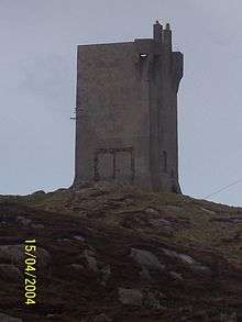
A military watchtower was built at Banba's Crown in 1805, during the Napoleonic Wars. Around 1902, a signal station was also built at Banba's Crown, quite close to the old Napoleonic watchtower. Both of these buildings still stand.
During World War II, the Irish Government allowed the British Government to site two radio direction finders on Malin Head. This top-secret operation was mentioned in The Cranborne Report. The RDF equipment was used to monitor U-Boat and aerial activity in the North Atlantic.
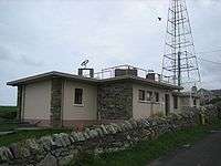
After the war, the site became a weather station for the Met Éireann and a Navtex transmitting station. Today, it is still used as a functioning weather station for the north west part of Ireland.
On a section of land jutting out from the mainland at Banba's Crown, the word 'Éire' can be seen in large letters that were formed from placing stones together to form the letters. This was to signify to overflying planes that they were passing Ireland and that Ireland was neutral.
Ornithology
Malin Head is an ideal vantage point from which to view the autumnal movements of seabirds such as gannets, shearwaters, skuas, auks and others, on their southward migration flights.
Gallery
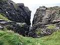 Hell's hole cavern.
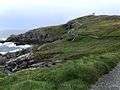 Malin head coastline looking towards the north.
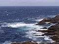 View of the rugged coast around the Head.
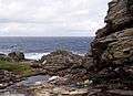 Low tide beneath the cliffs at Malin Head.
See also
| Wikimedia Commons has media related to Malin Head. |
References
- ↑ "Ireland Geographical Facts, Figures and Physical Extremities". Travel through the Ireland story... Retrieved 2007-09-15.
- ↑ http://www.romaneranames.uk/essays/ireland.pdf
- ↑ "See Ireland's most northerly point at Malin Head". Brilliant Ireland. Archived from the original on March 27, 2009.
- ↑ "Caffe Banba :: Ireland's Most Northerly Bakery & Coffee Shop". caffebanba.com.
- ↑ "Malin Head 1981–2010 averages". Met Éireann. Retrieved 27 May 2015.
- ↑ "Absolute Maximum Air Temperatures for each Month at Selected Stations" (PDF). Met Éireann. Retrieved 27 May 2015.
- ↑ "Absolute Minimum Air Temperatures for each Month at Selected Stations" (PDF). Met Éireann. Retrieved 27 May 2015.
- ↑ Sorcha Pollak, Tim O'Brien (26 May 2017). "Ireland set for another scorcher as heatwave continues". Irish Times. Retrieved 2017-05-26.