Islampur, Jagannathpur
| Islampur ইসলামপুর | |
|---|---|
| Village | |
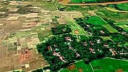 Bird's eye view of Islampur village | |
 Islampur Location of Islampur in Bangladesh | |
| Coordinates: 24°44′7.529″N 91°35′37.148″E / 24.73542472°N 91.59365222°ECoordinates: 24°44′7.529″N 91°35′37.148″E / 24.73542472°N 91.59365222°E | |
| Country |
|
| Division | Sylhet |
| District | Sunamganj |
| Upazila | Jagannathpur |
| Area | |
| • Total | 1.135 km2 (0.438 sq mi) |
| Population (2011) | |
| • Total | 993 |
| • Density | 870/km2 (2,300/sq mi) |
| Time zone | UTC+6 (BST) |
| Postal code | 3061 |
Islampur (Bengali: ইসলামপুর), also known as Brahman Gaon, is a village in Syedpur Shaharpara Union Parishad, Jagannathpur Upazila, Sunamganj District, Sylhet Division, Bangladesh. [1] [2] [3]
Demographics
According to Population Census 2011 performed by Bangladesh Bureau of Statistics, The total population is 993. There are households 165 in total.
Geography
Islampur is located at 24°44′7.529″N 91°35′37.148″E / 24.73542472°N 91.59365222°E . The total area of the Village is 1.135 km². Islampur village is bounded by Budhrail and Shaharpara on the north, Shewra and Alagdi on the south, Sunathonpur and Patkura on the east, Gosh Gaon and Thegoria on the west. [4]
Education
- Anuchandra Govt. Primary School
- Shah Jalal High School
Languages
The local people speaks Sylheti. Bangla and English languages are taught in the schools and the educated part of the population can understand and speak in English.
Picture Gallery
 Islampur Jame Mosjid
 Southfield During Golden Hour
 Islampur Jame Mosjid
 Islampur Jame Mosjid
 Islampur Jame Mosjid
See also
References
- ↑ History of Islampur 26-03-2016 (Bengali). Islampur. Retrieved on 06-02-2017.
- ↑ Islampur village 23-10-2017 (Bengali). Islampur. Retrieved on 06-02-2017.
- ↑ Google Satellite View of Islampur. Google.com. Retrieved on 06-02-2017.
- ↑ সৈয়দপুর শাহারপাড়া ইউনিয়ন পরিষদ, জাতীয় তথ্য বাতায়ন - গণপ্রজাতন্ত্রী বাংলাদেশ সরকার - People's Republic of Bangladesh (Bengali). syedpurshaharparaup.sunamganj.gov.bd. Retrieved on 06-02-2017.
External links