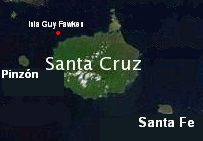
Isla Guy Fawkes
 | |
| Geography | |
|---|---|
| Location | Galápagos Islands |
| Coordinates | 0°30′55.69″S 90°31′37.90″W / 0.5154694°S 90.5271944°WCoordinates: 0°30′55.69″S 90°31′37.90″W / 0.5154694°S 90.5271944°W |
| Administration | |
|
Ecuador | |
| Demographics | |
| Population | Uninhabited |
Isla Guy Fawkes (also known as Guy Fawkes Island) is a collection of two crescent shaped islands and two small rocks north-west of Santa Cruz Island, in the Galápagos Islands, which are part of Ecuador.[1] It is uninhabited, but known to be used by scuba divers who amongst other things view the underwater zoanthids near it.[2]
William Beebe visited the islands and makes mention of them in his book Galapagos: World's End, he described the cliffs as majestic and made of stratified layers of volcanic tuff. He also noted a population of sealions.[3]
The island is perhaps best known and most noted for its name; which is derived from a controversial historical English figure.[4] Guy Fawkes, the man it is named after was a Roman Catholic revolutionary who had attempted to carry out the Gunpowder Plot in 1605.[5]
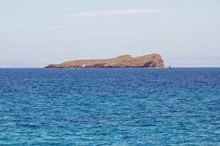 Isla Guy Fawkes Sur as seen from near Isla Santa Cruz
 Isla Guy Fawkes Norte as seen from near Isla Santa Cruz
References
- ↑ "Topography and Landforms of Ecuador" (PDF). Geology.er.usgs.gov. 24 October 2007. Archived from the original (PDF) on 16 February 2008.
- ↑ "Islas Galápagos Underwater Photography Gallery". RamblinCameras.com. 24 October 2007.
- ↑ Beebe, William. Galapagos: World's End. Dover Publications. ISBN 978-0-486-25642-9.
- ↑ "Island Names and Their Derivations". Galapagos.to. 24 October 2007. Archived from the original on 9 November 2007.
- ↑ "Transplanted Englishman brings countryís Guy Fawkes party tradition to Burnsville". ThisWeek-Online.com. 24 October 2007.
External links
| Main islands | |
|---|---|
| Minor islands | |
| Volcanoes | |
| |