Ishasha River
| Ishasha River | |
|---|---|
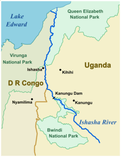 Course of the Ishasha River | |
 | |
| Country | Uganda, Democratic Republic of the Congo |
| Physical characteristics | |
| Main source |
Kabale District 6020 ft |
| River mouth |
Lake Edward 2995 ft Coordinates: 0°26′42″S 29°41′10″E / 0.445°S 29.686°E |
| Length | 100 km (approx) |
The Ishasha is a river in southwest Uganda, running from its source north of Kabale to its mouth at Lake Edward.[1][2] Its length is very roughly 100 kilometres (62 mi) ignoring the many small meanders.
Description
The river arises from drainage channels in farmland some 20 kilometres (12 mi) northwest of Kabale. It runs northwest through mountain valleys to its entrance into the northern lobe of Bwindi Impenetrable National Park. From there, it continues northwest under the heavy forest canopy to the Kanungu dam, part of the Kanungu Hydroelectric Power Station, also known as the Ishasha Power Station.
Leaving the power station, it meanders northwest through hilly terrain until it joins and becomes part of the Uganda-Democratic Republic of the Congo (DRC) border. After turning north, it continues past the DRC town of Ishasha at the southern tip of Queen Elizabeth National Park (QENP). It remains the western border of QENP until it enters the marshlands on the shore of Lake Edward.
Location
| Point | Coordinates (links to map & photo sources) |
Notes |
|---|---|---|
| Kabale District source | 1°05′S 29°53′E / 1.09°S 29.89°E | Elevation: 6020 ft |
| Entering Bwindi Impenetrable Forest | 0°57′22″S 29°46′41″E / 0.956°S 29.778°E | Elev: 4987 ft |
| Kanungu power station | 0°52′19″S 29°39′54″E / 0.872°S 29.665°E | Elev: 3554 ft |
| Uganda-DRC border | 0°50′02″S 29°38′20″E / 0.834°S 29.639°E | Elev: 3432 ft |
| Ishasha town | 0°44′06″S 29°37′48″E / 0.735°S 29.630°E | Elev: 3285 ft |
| Lake Edward mouth | 0°26′42″S 29°41′10″E / 0.445°S 29.686°E | Elev: 2995 ft |
See also
References
- ↑ "Southwestern Uganda". Google Maps. Google. Retrieved 10 June 2018.
- ↑ "Ishasha River course". Open Street Map. Retrieved 10 June 2018.