Isaac Hale Beach Park
| Isaac Hale Beach Park | |
|---|---|
 | |
 | |
| Coordinates | 19°27′27″N 154°50′28″W / 19.45750°N 154.84111°WCoordinates: 19°27′27″N 154°50′28″W / 19.45750°N 154.84111°W. |
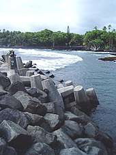
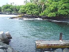
Isaac Hale Beach Park, also known as Pohoiki, is an oceanfront park, boat launch and surf location on Pohoiki Bay in the Puna district of the Big Island of Hawaii. It was one of only a few places on the southeastern shore of Hawaii that allows for such facilities. Pohoiki Bay is known for its strong currents, and although the park is known for good snorkeling, conditions are usually not ideal. The park was expanded and modernized in 2006.[1]
It is located at the intersection of the narrow Pohoiki road and the Kapoho-Kalapana road (Hawaii state route 137).
The park is named in honor of Private Isaac K. Hale. During the Korean War, Hale served in the United States Army's 19th Infantry Regiment, 24th Infantry Division. He was killed in action north of the 38th parallel on July 12, 1951.
2018 lower Puna Eruption
Lava flows from the 2018 lower Puna eruption are gradually encroaching towards the park. As of July 25, 2018, part of the park area had been covered by lava spreading from the northeast[2]. However, this lava never completely covered the park and when the eruption wound down early August the front of the lava was still several hundred feet away from the boat ramp. Now the boat launch is part of a new black sand beach that extends along Pohoiki Bay[3].
See also
References
- ↑ "Isaac Hale Beach Park". County of Hawaii Parks and Recreation.
- ↑ 2018 Lava Event (Map). Hawaii County. Retrieved 25 July 2018.
- ↑ "Pohoiki black sand beach". Love Big Island. Retrieved October 3, 2018.