Interstate 81 in Tennessee
| ||||
|---|---|---|---|---|
|
I-81 highlighted in red | ||||
| Route information | ||||
| Maintained by TDOT | ||||
| Length | 75.66 mi[1] (121.76 km) | |||
| Major junctions | ||||
| South end |
| |||
| North end |
| |||
| Location | ||||
| Counties | Jefferson, Hamblen, Greene, Washington, Sullivan | |||
| Highway system | ||||
| ||||

Interstate 81 (I-81) is an 855-mile (1,376 km) long expressway stretching from Dandridge, Tennessee northward to the Thousand Islands Bridge at the Canada–US border near Fishers Landing, New York. In Tennessee, I-81 travels 75.66 miles (121.76 km) from its southern terminus at I-40 in Dandridge to the Virginia state line in Bristol.
Route description
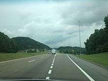
Interstate 81 begins in Tennessee at Interstate 40 in Dandridge. I-81 parallels the Appalachian Mountains for most of Tennessee and Virginia. At mile marker 8, I-81 meets U.S. Route 25E south of Morristown. I-81 doesn't go through either Johnson City or Kingsport; but at mile marker 57, I-81 meets Interstate 26 and U.S. Route 23 which go to Kingsport and Johnson City. At mile marker 75, I-81 leaves Tennessee and enters Virginia.
Auxiliary routes in Tennessee
| Interstate | City | Type | Notes | |
|---|---|---|---|---|
 |
Interstate 181 | Johnson City and Kingsport | Former spur | Was renumbered as Interstate 26 by March, 2007 |
History
Construction on I-81 in Tennessee began in the 1960s.[2] The contracts for most sections of the route were awarded in 1969 and 1970.[3] By December 1974, the entirety of the route was open to traffic, and most was completed.[4] The final section in Tennessee was completed in August 1975.[5]
Exit list
| County | Location | mi | km | Exit | Destinations | Notes |
|---|---|---|---|---|---|---|
| Jefferson | Dandridge | 0.00 | 0.00 | 1 | Southern terminus; I-40 exit 421; signed as left exit 1A (east) & 1B (west). | |
| White Pine | 4.4 | 7.1 | 4 | |||
| Hamblen | Morristown | 8.6 | 13.8 | 8 | ||
| 12.4 | 20.0 | 12 | ||||
| | 15.3 | 24.6 | 15 | |||
| Greene | Mosheim | 23.1 | 37.2 | 23 | Access to Tusculum College | |
| | 30.2 | 48.6 | 30 | |||
| Baileyton | 36.2 | 58.3 | 36 | |||
| Jearoldstown | 43.9 | 70.7 | 44 | Jearoldstown Road | ||
| Washington | Fall Branch | 50.5 | 81.3 | 50 | ||
| Sullivan | Kingsport | 56.1 | 90.3 | 56 | Tri-Cities Crossing | |
| 57.7 | 92.9 | 57 | Signed as Exits 57A (east) & 57B (west), I-26 exits 8A-B; former I-181 south | |||
| 59.4 | 95.6 | 59 | ||||
| 63.5 | 102.2 | 63 | Also access to Northeast State Community College | |||
| 66.1 | 106.4 | 66 | ||||
| Blountville | 69.6 | 112.0 | 69 | Access to Bristol Motor Speedway | ||
| Bristol | 74.8 | 120.4 | 74 | Signed as Exits 74A (north) & 74B (south) | ||
| 75.66 | 121.76 | Virginia state line | ||||
| 1.000 mi = 1.609 km; 1.000 km = 0.621 mi | ||||||
See also
References
- 2007 Rand McNally Atlas
- ↑ "Route Log - Main Routes of the Eisenhower National System Of Interstate and Defense Highways - Table 1". Federal Highway Administration. Retrieved 4 October 2014.
- ↑ "Where Do We Stand On The Interstate?". Kingsport Times-News. May 2, 1965.
- ↑ "81 Moving Along:Chamber". Kingsport Times-News. May 2, 1965. Retrieved 2018-06-18.
- ↑ "East Tennessee's Christmas Present". Kingsport Times-News. December 10, 1974. Retrieved 2018-06-18.
- ↑ "Interstate 81 Four-Lane Opens". Kingsport Times-News. August 28, 1975.
External links
Route map:

| Previous state: Terminus |
Tennessee | Next state: Virginia |