Inner Holm of Skaw
Coordinates: 60°23′13″N 0°54′47″W / 60.386889°N 0.912938°W
| Location | |
|---|---|
 Inner Holm of Skaw | |
| Coordinates | 60°23′12″N 0°54′46″W / 60.3868°N 0.9129°W |
| Physical geography | |
| Island group | Shetland |
| Highest elevation | 32 feet (9.8 m)[1] |
| Administration | |
| Sovereign state | United Kingdom |
| Country | Scotland |
| Council area | Shetland Islands |
| Demographics | |
| Population | 0 |
The Inner Holm of Skaw is a small, uninhabited islet off the northern tip of the island of Whalsay, in the Shetland Islands of Scotland, north of the village of Skaw.
Location
A kayakar may find their way through the rocks between the islet and the headland of Skaw Taing on Whalsay.[2] Further out to sea there is another rocky islet, the Outer Holm of Skaw.[3] The islet has a ruined chapel.[4] In 1955 a pair of Sandwich terns nested on the islet.[5]
See also
Gallery
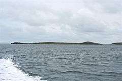 Inner Holm of Skaw
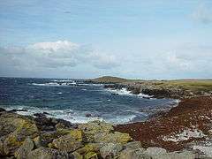 Looking across Wester Netlar to Sponger Point with the Inner Holm of Skaw beyond.
References
Citations
- ↑ United States. Hydrographic Office 1950, p. 311.
- ↑ Smith & Jex 2007, p. 215.
- ↑ Munro & Gittings 2006, p. 370.
- ↑ Haswell-Smith 2004, p. 454.
- ↑ Bannerman 1962, p. 137.
Sources
- Bannerman, David Armitage (1962). The birds of the British Isles. Oliver and Boyd. Retrieved 2013-02-04.
- Haswell-Smith, Hamish (2004-09-02). The Scottish islands: a comprehensive guide to every Scottish Island. Canongate. Retrieved 2013-02-04.
- Munro, David M.; Gittings, Bruce M. (2006). Scotland: an encyclopedia of places & landscapes. Collins. ISBN 978-0-00-472466-9. Retrieved 2013-02-04.
- Smith, Tom; Jex, Chris (15 March 2007). The Northern Isles: Orkney and Shetland Sea Kayaking. Pesda Press. ISBN 978-1-906095-00-0. Retrieved 4 February 2013.
- United States. Hydrographic Office (1950). Sailing directions for the north and east coasts of Scotland: Cape Wrath to Fife Ness and including the Orkney, Shetland and Faeroe Islands. U.S. Govt. Print. Off. Retrieved 4 February 2013.
| Wikimedia Commons has media related to Inner Holm of Skaw. |
| Settlements | ||
|---|---|---|
| Geography |
| |
| Archaeological sites | ||
| Buildings | ||
This article is issued from
Wikipedia.
The text is licensed under Creative Commons - Attribution - Sharealike.
Additional terms may apply for the media files.