Ink, Arkansas
| Ink, Arkansas | |
|---|---|
| Unincorporated community | |
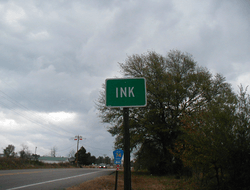 Road marker for Ink | |
 Ink, Arkansas  Ink, Arkansas | |
| Coordinates: 34°35′14″N 94°07′27″W / 34.58722°N 94.12417°WCoordinates: 34°35′14″N 94°07′27″W / 34.58722°N 94.12417°W | |
| Country | United States |
| State | Arkansas |
| County | Polk |
| Elevation | 1,033 ft (315 m) |
| Time zone | UTC-6 (Central (CST)) |
| • Summer (DST) | UTC-5 (CDT) |
| Area code(s) | 479 |
| GNIS feature ID | 72147[1] |
Ink is an unincorporated community in Polk County, Arkansas, United States.[1] The elevation of Ink is 1033 feet.[2]
A popular and apocryphal story of how the town got its name in 1887 is one based on a misunderstanding. When the townsfolk were completing the government application to establish a post office, they interpreted the instruction "Please write in ink" literally and entered the name "Ink" as the proposed town name.[3] This was accepted as the official name.[4]
The true story is that many towns were trying to register at the same time, and the United States Postal Service was trying very hard to limit the number of duplicate place names. Postmasters of the various post offices trying to register their towns were required to give several name alternatives. Most towns did not get their first, second, or even third choices. Ink was actually the second choice, the first being "Melon."[5]
References
- 1 2 "Ink, Arkansas". Geographic Names Information System. United States Geological Survey.
- ↑ Arkansas Hometown Locator. Retrieved May 2009.
- ↑ Remington, Frank L. (Sep 8, 1969). "Take a Good Look at the US Map. Towns Have the Craziest Names". The Milwaukee Journal. p. 1. Retrieved 18 May 2015.
- ↑ "Colorful Names". Arkansas Department of Parks & Tourism. Archived from the original on November 24, 2013. Retrieved 14 July 2014.
- ↑ HOW THE TOWN OF INK, ARKANSAS GOT ITS NAME. Retrieved April 2013.
Municipalities and communities of Polk County, Arkansas, United States | ||
|---|---|---|
| Cities | 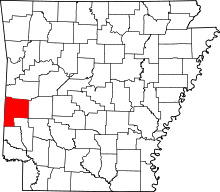 | |
| Towns | ||
| Unincorporated communities | ||