Indiana State Road 301
| ||||
|---|---|---|---|---|
 | ||||
| Route information | ||||
| Maintained by INDOT | ||||
| Length | 9.582 mi[1] (15.421 km) | |||
| Major junctions | ||||
| South end |
| |||
| North end |
| |||
| Highway system | ||||
| ||||

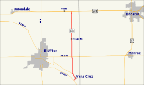
State Road 301 in the U.S. state of Indiana is a short north–south route in Wells County in the northeastern part of the state.
Route description
SR 301 begins at SR 116 south of the town of Vera Cruz and travel northeast crossing the Wabash River, before entering Vera Curz. In the town SR 301 is concurrent with Center Street before turning northwest onto Wabash Street and leaving town. SR 301 logs its lowest average annual daily traffic (AADT) counts. The 2016 AADT figures show that 386 vehicles use the highway per day between Center Street and SR 124.[2] Northwest of Vera Cruz the road passes through farmland before turning due north paralleling the east side of Ouabache State Park. The highway has an intersection with SR 124, before passing through Craigville. According to INDOT, the segment just north of SR 124 logged the highway's highwast AADT, only 963 vehicles per day, in 2016.[2] In Craigville SR 301 crosses over the Wabash Central Railroad track.[3] North of Craigsville the route continues through farmland before terminating at U.S. Route 224 about a mile east of Tocsin.[4]
Major intersections
The entire route is in Wells County.
| Location | mi[1] | km | Destinations | Notes | |
|---|---|---|---|---|---|
| Harrison Township | 0.000 | 0.000 | Southern terminus of SR 301 | ||
| Lancaster Township | 3.529 | 5.679 | |||
| 9.582 | 15.421 | Northern terminus of SR 301 | |||
| 1.000 mi = 1.609 km; 1.000 km = 0.621 mi | |||||
References
- 1 2 Indiana Department of Transportation (July 2015). Reference Post Book (PDF). Indianapolis: Indiana Department of Transportation. Retrieved October 4, 2016.
- 1 2 Indiana Department of Transportation (2016). "Traffic Count Database System". Indianapolis: Indiana Department of Transportation. Retrieved December 22, 2016.
- ↑ Indiana Department of Transportation (January 30, 2014). State of Indiana 2014 Rail System Map (PDF) (Map). Scale not given. Indianapolis: Indiana Department of Transportation. Retrieved December 22, 2016.
- ↑ Indiana Department of Transportation (2016). Indiana Roadway Map 2016 (PDF) (Map). 1:550,000. Indianapolis: Indiana Department of Transportation. OCLC 925532510. Retrieved December 22, 2016.
External links
Route map: