Illar, Tulkarm
| 'Illar | |
|---|---|
| Other transcription(s) | |
| • Arabic | عِلار |
 | |
 'Illar Location of 'Illar within Palestine | |
| Coordinates: 32°22′13″N 35°06′27″E / 32.37028°N 35.10750°ECoordinates: 32°22′13″N 35°06′27″E / 32.37028°N 35.10750°E | |
| Palestine grid | 160/197 |
| Governorate | Tulkarm |
| Government | |
| • Type | Municipality |
| Area | |
| • Jurisdiction | 13,981 dunams (14 km2 or 5 sq mi) |
| Population (2007[1]) | |
| • Jurisdiction | 6,190 |
| Name meaning | from personal name[2] |
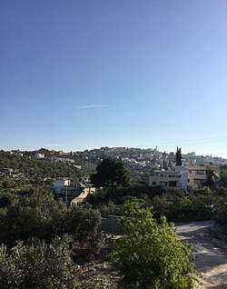
'Illar (Arabic: عِلار) is a Palestinian town in the Tulkarm Governorate in the northern West Bank, located 10 kilometers northeast of Tulkarm, and 25 kilometers east of the Israeli city of Netanya. It is bordered by Attil to the west, Kafr Ra'i to the east, and the Israeli settlement of Hermesh to the north. According to the Palestinian Central Bureau of Statistics, 'Illar had a population of approximately 6,190 inhabitants in 2007.[1] 6.6% of the population of 'Illar were refugees in 1997.[3] The healthcare facilities for the surrounding villages are based in 'Illar, the facilities are designated as MOH level 2.[4]
History
Pottery remains from the Iron Age II, Hellenistic, early and late Roman, Byzantine, early Muslim and the Middle Ages have been found here.[5]
In 1200, during the Crusader era, it was known as Allar.[5] In 1265, it was mentioned among the estates which Sultan Baibars granted his amirs after he had expelled the Crusaders.[5] The whole of Illar was given to his emir Saif al-Din Qushtimur al-'Ajami.[6]
Ottoman era
Illar, like the rest of Palestine, was incorporated into the Ottoman Empire in 1517, and in the census of 1596 it was a part of the nahiya ("subdistrict") of Jabal Sami which was under the administration of the liwa ("district") of Nablus. The village had a population of 41 households, all Muslim. The villagers paid a fixed tax-rate of 33,3% on agricultural products, such as wheat, barley, summer crops, olive trees, beehives and/or goats, in addition to occasional revenues; a total of 5,074 akçe. All of the revenue went to a Waqf.[7]
In 1882, the Palestine Exploration Fund's Survey of Western Palestine described it as "a small village on the side of a hill, with olives and wells."[8]
British Mandate era
In the 1922 census of Palestine conducted by the British Mandate authorities, Allar had a population of 835, all Muslims,[9] increasing in the 1931 census to 1047 Muslims, in 268 houses.[10]
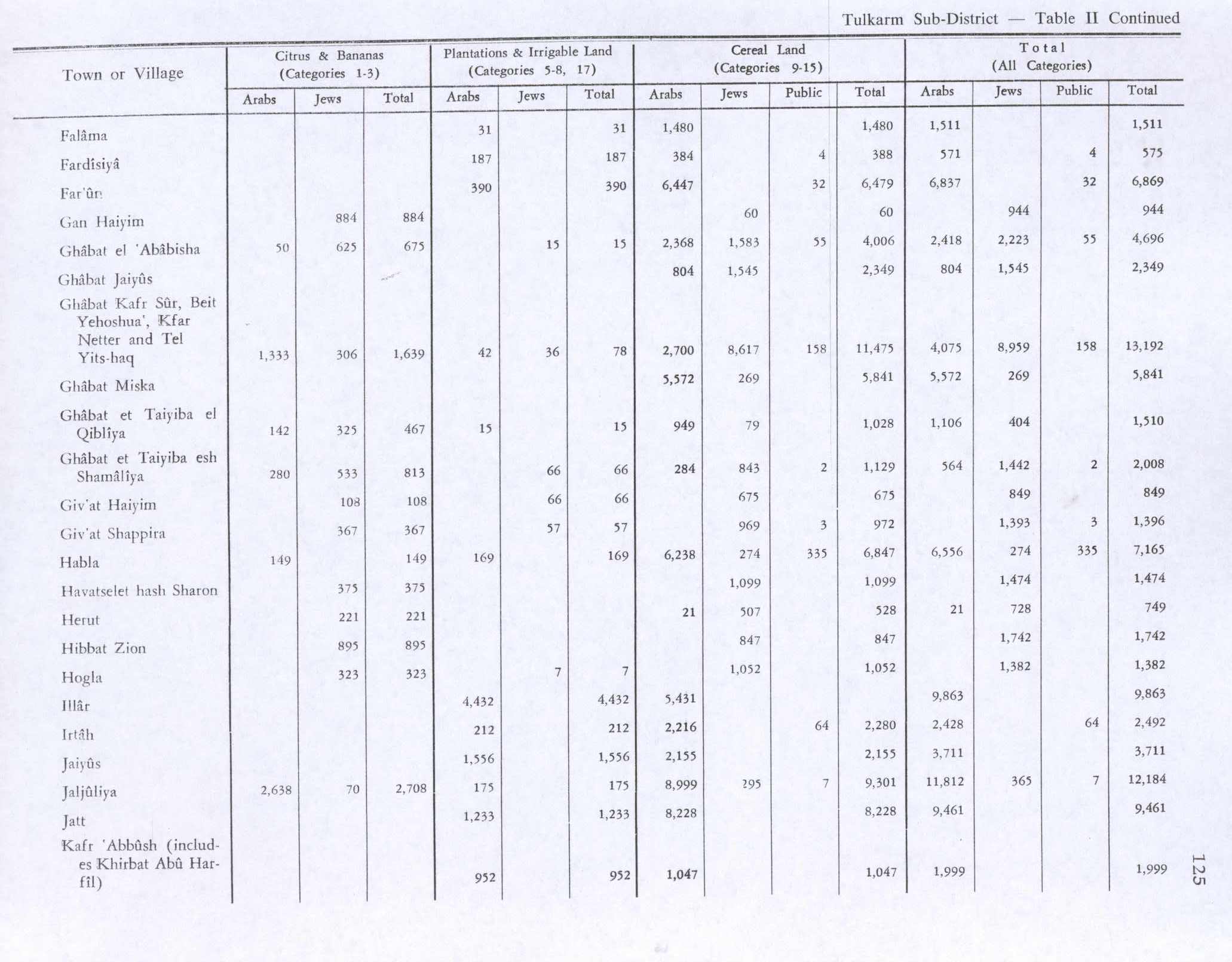
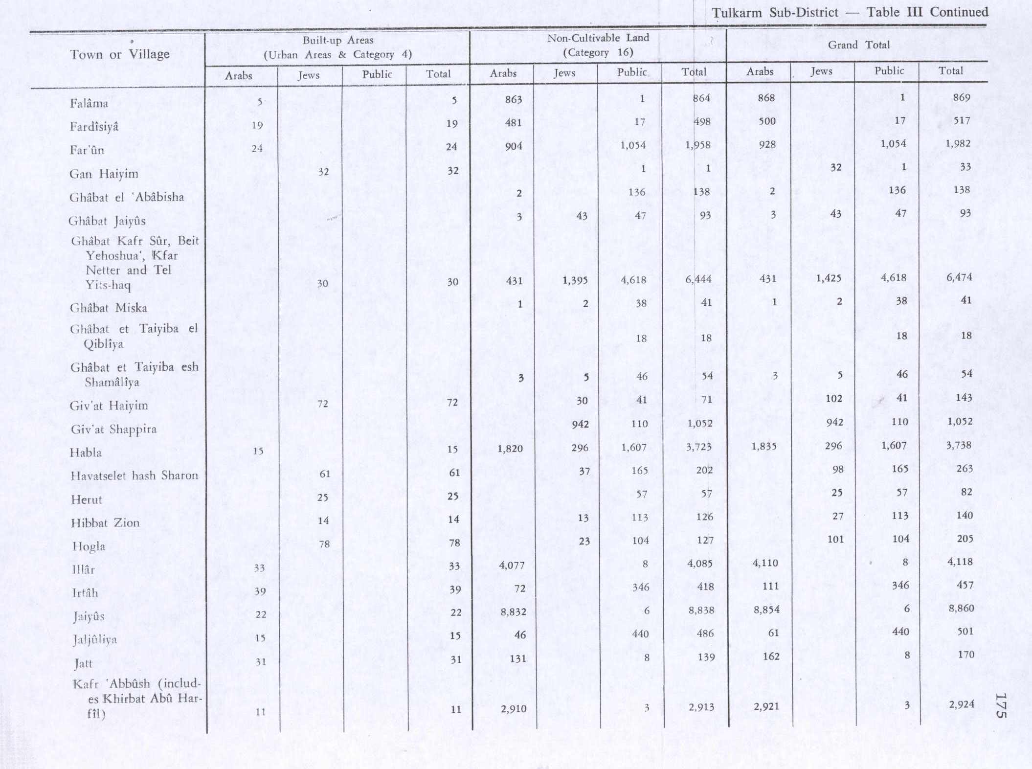
In the 1945 statistics the population of Illar was 1,450, all Muslims,[11] with 13,981 dunams of land according to an official land and population survey.[12] 4,432 dunams were plantations and irrigable land, 5,431 used for cereals,[13] while 33 dunams were built-up (urban) land.[14]
Jordanian era
In the wake of the 1948 Arab–Israeli War, and after the 1949 Armistice Agreements, Illar came under Jordanian rule.
In 1961, the population of Illar was 2,499.[15]
Post-1967
After the Six-Day War in 1967, Illar has been under Israeli occupation.
After Oslo II Accord in 1995, Illar was placed under Area A of the West Bank under security and civil administration of the Palestinian National Authority.
Footnotes
- 1 2 "Archived copy" (PDF). Archived from the original (PDF) on 2010-12-10. Retrieved 2010-06-16. Palestinian Central Bureau of Statistics.
- ↑ Palmer, 1881, p. 182
- ↑ Palestinian Population by Locality and Refugee Status Archived 2012-02-07 at the Wayback Machine. Palestinian Central Bureau of Statistics
- ↑ Health care Facilities Tulkarm Governorate
- 1 2 3 Zertal, 2016, pp. 419-421
- ↑ Ibn al-Furat, 1971, pp. 81, 209, 249 (map)
- ↑ Hütteroth and Abdulfattah, 1977, p. 126
- ↑ Conder and Kitchener, 1882, p. 154
- ↑ Barron, 1923, Table XI, Sub-district of Tulkarm, p. 27
- ↑ Mills, 1932, p.55
- ↑ Government of Palestine, Department of Statistics, 1945, p. 20
- ↑ Government of Palestine, Department of Statistics. Village Statistics, April, 1945. Quoted in Hadawi, 1970, p. 75
- ↑ Government of Palestine, Department of Statistics. Village Statistics, April, 1945. Quoted in Hadawi, 1970, p. 125
- ↑ Government of Palestine, Department of Statistics. Village Statistics, April, 1945. Quoted in Hadawi, 1970, p. 175
- ↑ Government of Jordan, Department of Statistics, 1964, p. 14
Bibliography
- Barron, J.B., ed. (1923). Palestine: Report and General Abstracts of the Census of 1922. Government of Palestine.
- Conder, C.R.; Kitchener, H.H. (1882). The Survey of Western Palestine: Memoirs of the Topography, Orography, Hydrography, and Archaeology. 2. London: Committee of the Palestine Exploration Fund.
- Government of Jordan, Department of Statistics (1964). First Census of Population and Housing. Volume I: Final Tables; General Characteristics of the Population (PDF).
- Government of Palestine, Department of Statistics (1945). Village Statistics, April, 1945.
- Hadawi, S. (1970). Village Statistics of 1945: A Classification of Land and Area ownership in Palestine. Palestine Liberation Organization Research Center.
- Hütteroth, Wolf-Dieter; Abdulfattah, Kamal (1977). Historical Geography of Palestine, Transjordan and Southern Syria in the Late 16th Century. Erlanger Geographische Arbeiten, Sonderband 5. Erlangen, Germany: Vorstand der Fränkischen Geographischen Gesellschaft. ISBN 3-920405-41-2.
- Ibn al-Furat (1971). J. Riley-Smith, ed. Ayyubids, Mamluks and Crusaders: Selections from the "Tarikh Al-duwal Wal-muluk" of Ibn Al-Furat : the Text, the Translation. 2. Translation by Malcolm Cameron Lyons, Ursula Lyons. Cambridge: W. Heffer.
- Mills, E., ed. (1932). Census of Palestine 1931. Population of Villages, Towns and Administrative Areas. Jerusalem: Government of Palestine.
- Palmer, E.H. (1881). The Survey of Western Palestine: Arabic and English Name Lists Collected During the Survey by Lieutenants Conder and Kitchener, R. E. Transliterated and Explained by E.H. Palmer. Committee of the Palestine Exploration Fund.
- Zertal, A. (2016). The Manasseh Hill Country Survey. 3. Boston: BRILL. ISBN 9004312307.
External links
- Welcome To 'Illar
- Survey of Western Palestine, Map 11: IAA, Wikimedia commons
