The estimated hydropower potential of the lower Mekong Basin (i.e., excluding China) is 30,000 MW,[1][2] while that of the upper Mekong Basin is 28,930 MW.[3] In the lower Mekong, more than 3,235 MW has been realized via facilities built largely over the past ten years, while projects under construction will represent an additional 3,209 MW. An additional 134 projects are planned for the lower Mekong, which will maximize the river's hydropower generating capacity.[4] The single most significant impact—both now and in the future—on the use of water and its management in the Mekong Region is hydropower.[5]
Given current development trends in the region, power demands are expected to rise seven percent per year between 2010 and 2030,[2] yielding a substantial and potentially lucrative energy market. Hydropower is the favoured energy option for the Mekong's riparian countries.[6][7]
The development of the Mekong River Basin is highly controversial[8][9], and is one of the most prominent components in the discussion about the river and its management. This debate occurs in both the academic literature, as well as the media, and is a focus for many activist groups.[10][11][12]
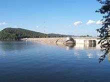
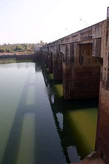
Existing hydropower infrastructure
Table 1: Commissioned dams in the Mekong River Basin (15 MW installed capacity and above)[13]
| Project | Country | River | Location | Commissioned | Installed capacity (MW) | Mean Annual Energy (GW) | Height (m) | Crest length (m) | Total storage (million m3) | Max reservoir area (km2) |
| Dachaoshan |  | Mekong | 24°01′30″N 100°22′13″E / 24.024947°N 100.3703°E / 24.024947; 100.3703 (Dachaoshan Dam) | 2003 | 1,350 | 5,500 | 115 | 481 | 890 | 26.25 |
| Gongguoqiao | | Mekong | 25°35′09″N 99°20′08″E / 25.585917°N 99.335567°E / 25.585917; 99.335567 (Gongguoqiao Dam) | 2012 | 900 | 4,041 | 105 | 356 | 316 | 343 |
| Nuozhadu | | Mekong | 22°38′32″N 100°26′11″E / 22.642128°N 100.436336°E / 22.642128; 100.436336 (Nuozhadu Dam) | 2014 | 5,850 | 23,912 | 262 | 608 | 23,703 | 320 |
| Jinghong | | Mekong | 22°03′12″N 100°45′59″E / 22.053206°N 100.766478°E / 22.053206; 100.766478 (Jinghong Dam) | 2009 | 1,750 | 5,570 | 108 | 705.5 | 1,140 | 510 |
| Manwan | | Mekong | 24°37′20″N 100°26′55″E / 24.622086°N 100.448544°E / 24.622086; 100.448544 (Manwan Dam) | 1995 | 1,570 | 6,710 | 132 | 418 | 920 | 415 |
| Xiaowan | | Mekong | 24°42′15″N 100°05′29″E / 24.7042226°N 100.091255°E / 24.7042226; 100.091255 (Xiaowan Dam) | 2010 | 4,200 | 18,990 | 295 | 893 | 14,560 | 194 |
| Jinfeng | | Nan La He | 21°35′31″N 101°13′30″E / 21.592026°N 101.225135°E / 21.592026; 101.225135 (Jinfeng Dam) | 1998 | 16 | 64.3 | 45 | | 19.48 | |
| Jinhe | | Jin He | 30°48′22″N 97°19′59″E / 30.806181°N 97.332926°E / 30.806181; 97.332926 (Jinhe Dam) | 2004 | 60 | 367 | 34 | 68.4 | 4.27 | |
| Guoduo | | Mekong | 31°31′45″N 97°11′29″E / 31.529089°N 97.191279°E / 31.529089; 97.191279 (Guoduo Dam) | 2015 | 160 | 823 | 93 | 235.5 | 83 | |
| Laoyinyan | | Gua Lan Zi He/Shun Dian He | 24°28′09″N 99°49′03″E / 24.469128°N 99.81754°E / 24.469128; 99.81754 (Laoyinyan Dam) | 1997 | 16 | | 4.2 | | 1,092 | |
| Nanhe 1 | | Luo Zha He | 24°20′33″N 100°00′44″E / 24.342442°N 100.012183°E / 24.342442; 100.012183 (Nanhe 1 Dam) | 2009 | 40 | 170 | 56.8 | 148 | 11.36 | |
| Nanhe 2 | | Luo Zha He | 24°22′38″N 100°03′00″E / 24.377086°N 100.050098°E / 24.377086; 100.050098 (Nanhe 2 Dam) | ? | 25 | 100 | | | | |
| Luozhahe 1 | | Luo Zha He | 24°30′19″N 100°27′06″E / 24.505207°N 100.451749°E / 24.505207; 100.451749 (Luozhahe 1 Dam) | 2016 | 30 | 135 | 59 | | 14.33 | |
| Xi'er He 1 | | Xi'er He | 25°34′44″N 100°12′09″E / 25.578801°N 100.202419°E / 25.578801; 100.202419 (Xi'er He 1 Dam) | 1979 | 105 | 440 | | | | |
| Xi'er He 2 | | Xi'er He | 25°33′43″N 100°07′52″E / 25.561991°N 100.131191°E / 25.561991; 100.131191 (Xi'er He 2 Dam) | 1987 | 50 | | 37 | 122 | 0.2 | |
| Xi'er He 3 | | Xi'er He | 25°33′31″N 100°06′28″E / 25.558584°N 100.107878°E / 25.558584; 100.107878 (Xi'er He 3 Dam) | 1988 | 50 | 223 | 21 | | | |
| Xi'er He 4 | | Xi'er He | 25°34′35″N 100°03′56″E / 25.576262°N 100.065574°E / 25.576262; 100.065574 (Xi'er He 4 Dam) | 1971 | | | | | 14 | |
| XunCun | | Hei Hui Jiang | 25°25′19″N 99°59′36″E / 25.421835°N 99.993301°E / 25.421835; 99.993301 (XunCun Dam) | 1999 | 78 | 345 | 67 | 165 | 74 | |
| Houay Ho |  | Houayho/Xekong | 15°03′34″N 106°45′52″E / 15.059464°N 106.764377°E / 15.059464; 106.764377 (Houayho Dam) | 1999 | 152 | 450 | 79 | | 3,530 | 37 |
| Houay Lamphan | | Xekong | 15°21′22″N 106°30′04″E / 15.356153°N 106.501106°E / 15.356153; 106.501106 (Houay Lamphan Dam) | 2015 | 88 | 480 | 77 | 74.5 | 140 | 9 |
| Nam Beng | | Nam Beng | 19°56′47″N 101°14′15″E / 19.946436°N 101.237563°E / 19.946436; 101.237563 (Nam Beng Dam) | 2014 | 36 | 145 | 25.5 | 84.8 | 3,611 | 0.7 |
| Nam Khan 2 | | Nam Khan | 19°41′07″N 102°22′11″E / 19.685364°N 102.369791°E / 19.685364; 102.369791 (Nam Khan 2 Dam) | 2015 | 130 | 225 | 160 | 405 | | 30.5 |
| Nam Khan 3 | | Nam Khan | 19°44′49″N 102°13′22″E / 19.747016°N 102.222793°E / 19.747016; 102.222793 (Nam Khan 3 Dam) | 2016 | 88 | 480 | 77 | 74.5 | 140 | 9 |
| Nam Leuk | | Nam Leuk/Nam Ngum | 18°26′15″N 102°56′48″E / 18.437406°N 102.94675°E / 18.437406; 102.94675 (Nam Leuk Dam) | 2000 | 60 | 215 | 51.5 | 800 | 185 | 17.2 |
| Nam Lik 1-2 | | Nam Lik | 18°47′38″N 102°07′00″E / 18.793782°N 102.116714°E / 18.793782; 102.116714 (Nam Lik 1-2 Dam) | 2010 | 100 | 435 | 103 | 328 | 11 | 24.4 |
| Nam Mang 1 | | Nam Mang | 18°32′03″N 103°11′47″E / 18.53423°N 103.196286°E / 18.53423; 103.196286 (Nam Mang 1 Dam) | 2016 | 64 | 225 | 70 | 280 | 16.5 | 0.148 |
| Nam Mang 3 | | Nam Gnogn | 18°20′58″N 102°45′55″E / 18.349383°N 102.765244°E / 18.349383; 102.765244 (Nam Mang 3 Dam) | 2004 | 40 | 150 | 28 | 151 | 49 | 10 |
| Nam Ngiep 2 | | Nam Ngiep | 19°18′00″N 103°21′08″E / 19.299877°N 103.352263°E / 19.299877; 103.352263 (Nam Ngiep 2 Dam) | 2015 | 180 | 732 | | | | |
| Nam Ngiep 3A | | Nam Ngiep | 19°14′37″N 103°17′02″E / 19.243546°N 103.283913°E / 19.243546; 103.283913 (Nam Ngiep 3A Dam) | 2014 | 44 | 152 | | | | 1.8 |
| Nam Ngum 1 | | Nam Ngum | 18°31′52″N 102°32′51″E / 18.531068°N 102.547577°E / 18.531068; 102.547577 (Nam Ngum 1 Dam) | 1971 | 148.7 | 1,006 | 75 | 468 | 4,700 | 370 |
| Nam Ngum 2 | | Nam Ngum | 18°45′19″N 102°46′35″E / 18.755374°N 102.776476°E / 18.755374; 102.776476 (Nam Ngum 2 Dam) | 2011 | 615 | 2,300 | 182 | 421 | 3,590 | 122.2 |
| Nam Ngum 5 | | Nam Ngum | 19°21′22″N 102°37′16″E / 19.356095°N 102.621196°E / 19.356095; 102.621196 (Nam Ngum 5 Dam) | 2012 | 120 | 507 | 99 | 235 | 314 | 15 |
| Nam Theun 2 | | Nam Theun/Xe Bangfai | 17°59′50″N 104°57′08″E / 17.997353°N 104.952306°E / 17.997353; 104.952306 (Nam Theun 2 Dam) | 2010 | 1,075 | 5,936 | 48 | 325 | 3,500 | 450 |
| Nam Ou 2 | | Nam Ou | 20°24′42″N 102°28′22″E / 20.411698°N 102.472817°E / 20.411698; 102.472817 (Nam Ou 2 Dam) | 2016 | 120 | 546 | 49 | 352 | 121.7 | 15.7 |
| Nam Ou 5 | | Nam Ou | 21°24′41″N 102°20′39″E / 21.411349°N 102.344263°E / 21.411349; 102.344263 (Nam Ou 5 Dam) | 2016 | 240 | 1,049 | 74 | | 335 | 17.22 |
| Nam Ou 6 | | Nam Ou | 21°24′41″N 102°20′39″E / 21.411349°N 102.344263°E / 21.411349; 102.344263 (Nam Ou 6 Dam) | 2016 | 180 | 739 | 88 | | 409 | 17.01 |
| Theun-Hinboun | | Nam Theun | 18°15′40″N 104°33′45″E / 18.261005°N 104.562525°E / 18.261005; 104.562525 (Theun-Hinboun Hydropower Plant) | 1998 | 220 | 1,645 | 48 | 810 | 1,300 | 49 |
| Theun-Hinboun Expansion Project | | Nam Gnouang | 18°17′50″N 104°38′10″E / 18.297248°N 104.636171°E / 18.297248; 104.636171 (Theun-Hinboun Expansion Project) | 2013 | 222 | 1,395 | 65 | 480 | 2,450 | 49 |
| Xe Kaman 3 | | Xe Kaman | 15°25′31″N 107°21′45″E / 15.425194°N 107.362611°E / 15.425194; 107.362611 (Xe Kaman 3 Dam) | 2014 | 250 | 1,000 | 102 | 543 | 141.5 | 5.2 |
| Xeset 1 | | Xeset | 15°29′31″N 106°16′43″E / 15.49200°N 106.27867°E / 15.49200; 106.27867 (Xeset 1 Dam) | 1994 | 45 | 154 | 18 | 124 | | |
| Xeset 2 | | Xeset | 15°24′14″N 106°16′49″E / 15.403775°N 106.280332°E / 15.403775; 106.280332 (Xeset 1 Dam) | 2009 | 76 | 309 | 26 | 144 | | |
| A Luoi |  | A Sap | 16°11′51″N 107°09′43″E / 16.197619°N 107.161897°E / 16.197619; 107.161897 (A Luoi Dam) | 2012 | 170 | 686 | 49.5 | 208 | | |
| Buon Kuop | | Sre Pok | 12°31′30″N 107°55′33″E / 12.52504°N 107.925762°E / 12.52504; 107.925762 (Buon Kop Dam) | 2009 | 280 | 1,455 | | | | 47 |
| Buon Tua Sra | | Se San/Krong Po Ko | 12°16′56″N 108°02′29″E / 12.282116°N 108.041299°E / 12.282116; 108.041299 (Buon Tua Srah Dam) | 2009 | 86 | 359 | | | | 41 |
| Dray Hlinh 2 | | Sre Pok | 12°40′33″N 107°54′14″E / 12.6757°N 107.903978°E / 12.6757; 107.903978 (Dray Hinh 2 Dam) | 2007 | 16 | 85 | | | | |
| Plei Krong | | Se San/Krong Po Ko | 14°24′30″N 107°51′47″E / 14.408227°N 107.862991°E / 14.408227; 107.862991 (Plei Krong Dam) | 2008 | 100 | 479 | 65 | 745 | 1,049 | 53 |
| Sesan 3 | | Sesan | 14°12′57″N 107°43′19″E / 14.215816°N 107.722061°E / 14.215816; 107.722061 (Sesan 3 Dam) | 2006 | 260 | 1,224 | 79 | | | 6.4 |
| Sesan 3A | | Sesan | 14°12′55.13″N 107°43′20.15″E / 14.2153139°N 107.7222639°E / 14.2153139; 107.7222639 (Sesan 3A Dam) | 2007 | 96 | | | | | |
| Sesan 4 | | Sesan | 14°6′23.02″N 107°39′28.08″E / 14.1063944°N 107.6578000°E / 14.1063944; 107.6578000 (Sesan 4 Dam) | 2009 | 360 | 60 | | | 54 | |
| Sre Pok 3 | | Sre Pok | 12°45′2.78″N 107°52′34.32″E / 12.7507722°N 107.8762000°E / 12.7507722; 107.8762000 (Sre Pok 3 Dam) | 2009 | 220 | 52.5 | | | | |
| Yali Falls | | Sesan | 14°13′38.93″N 107°49′46.55″E / 14.2274806°N 107.8295972°E / 14.2274806; 107.8295972 (Yali Falls Dam) | 2001 | 720 | 65 | 1,460 | 1,037 | 64.5 | |
| Chulabhorn |  | Nam Phrom | 16°32′11″N 101°39′00″E / 16.536267°N 101.650036°E / 16.536267; 101.650036 (Chulabhorn Dam) | 1972 | 40 | 93 | 70 | 700 | 165 | 31 |
| Pak Mun | | Mun | 15°16′55″N 105°28′05″E / 15.2818942°N 105.468058°E / 15.2818942; 105.468058 (Pak Mun Dam) | 1994 | 136 | 280 | 17 | 300 | | |
| Sirindhorn | | Lam Dom Noi | 15°12′23″N 105°25′45″E / 15.206339°N 105.429156°E / 15.206339; 105.429156 (Siridhorn Dam) | 1971 | 36 | 86 | 42 | 940 | 1,967 | 288 |
| Ubol Ratana | | Nam Pong | 16°46′31″N 102°37′06″E / 16.775394°N 102.618325°E / 16.775394; 102.618325 (Ubol Ratana Dam) | 1966 | 25.2 | 57 | 35.1 | 885 | 2,559 | 410 |
| Lam Ta Khong | | Lam Ta Khong | 14°51′55″N 101°33′37″E / 14.865175°N 101.560303°E / 14.865175; 101.560303 (Lam Ta Khong Dam) | 1974 | 500 | 400 | 40.3 | 251 | 310 | 37 |
Hydropower infrastructure under construction
Table 2: Hydropower dams under construction in the Mekong River Basin (15 MW installed capacity and above)[13]
| Project | Country | River | Location | Expected Commissioning Year | Installed capacity (MW) | Mean Annual Energy (GW) | Height (m) | Crest length (m) | Total storage (million m3) | Max reservoir area (km2) |
| Dahuaqiao | | Mekong | 26°18′29″N 99°08′21″E / 26.308096°N 99.139288°E / 26.308096; 99.139288 (Dahuaqiao Dam) | 2018 | 920 | 4,070 | 106 | 231.5 | 293 | |
| Huangdeng | | Mekong | 26°32′54″N 99°06′46″E / 26.548199°N 99.112669°E / 26.548199; 99.112669 (Huangdeng Dam) | 2018 | 1,900 | 8,578 | 203 | 457 | 1,613 | |
| Lidi | | Mekong | 27°50′53″N 99°01′50″E / 27.848016°N 99.030555°E / 27.848016; 99.030555 (Lidi Dam) | 2019 | 420 | 1,753 | 75 | 346.4 | 75 | 3.7 |
| Luozhahe 2 | | Luo Zha He | 24°29′13″N 100°24′08″E / 24.486867°N 100.402128°E / 24.486867; 100.402128 (Luozhahe 2 Dam) | 2017 | 50 | 225 | 71 | | 3,391 | |
| Miaowei | | Mekong | 25°51′15″N 99°09′47″E / 25.854121°N 99.163155°E / 25.854121; 99.163155 (Miaowei Dam) | 2017[14] | 1,400 | 5,999 | 140 | | 660 | |
| Wunonglong | | Mekong | 27°55′57″N 98°56′00″E / 27.932554°N 98.9333°E / 27.932554; 98.9333 (Wunonglong Dam) | 2019 | 990 | 4,116 | 138 | 247 | 284 | |
| Ganlanba | | Mekong | 21°50′38″N 100°56′17″E / 21.843867°N 100.937917°E / 21.843867; 100.937917 (Ganlanba Dam) | 2018[15] | 155 | 1,177 | 60.5 | 458 | 577 | 58 |
| Don Sahong | | Mekong | 13°57′22″N 105°57′51″E / 13.956223°N 105.964247°E / 13.956223; 105.964247 (Don Sahong Dam) | 2019 | 256 | 2,000 | 25 | 6,800 | 25 | 2.2 |
| Houay Por | | Houay Pore | 15°32′44″N 106°15′24″E / 15.545605°N 106.256763°E / 15.545605; 106.256763 (Houay Por Dam) | unknown | 15 | 60 | 6 | | 0.76 | |
| Nam Bi 1 | | Nam Bi | 15°14′08″N 107°30′57″E / 15.23565°N 107.515959°E / 15.23565; 107.515959 (Nam Bi 1 Dam) | 2021 | 50 | 210 | 25 | 84 | 3 | 0.0273 |
| Nam Bi 2 | | Nam Bi | 15°12′44″N 107°32′27″E / 15.212256°N 107.540761°E / 15.212256; 107.540761 (Nam Bi 2 Dam) | 2021 | 68 | 288.5 | 47.5 | 182.5 | 10 | 0.64 |
| Nam Chian 1 | | Nam Ngiep | 19°08′43″N 103°33′26″E / 19.145395°N 103.557259°E / 19.145395; 103.557259 (Nam Chian 1 Dam) | 2017 | 104 | 448 | 69 | 367 | | |
| Nam Kong 2 | | Nam Kong | 14°29′41″N 106°51′24″E / 14.494672°N 106.856669°E / 14.494672; 106.856669 (Nam Kong Dam 2) | 2021 | 66 | 264 | 50 | 210 | 71.4 | 4.2 |
| Nam Kong 3 | | Nam Kong | 14°33′59″N 106°54′45″E / 14.566338°N 106.912551°E / 14.566338; 106.912551 (Nam Kong 3 Dam) | 2017 | 45 | 170 | | | 50.5 | |
| Nam Ngiep 1 | | Nam Ngiep | 18°38′45″N 103°33′06″E / 18.6458578°N 103.5516582°E / 18.6458578; 103.5516582 (Nam Ngiep 1 Dam) | 2019 | 272 | 1,546 | 167 | 530 | 1,192 | 67 |
| Nam Ngiep 2C | | Nam Ngiep | 19°12′48″N 103°21′28″E / 19.21347°N 103.357806°E / 19.21347; 103.357806 (Nam Ngiep 2C Dam) | 2020 | 45 | 230 | | | | |
| Nam Ngiep (Downstream) | | Nam Ngiep | 18°38′51″N 103°31′00″E / 18.64747°N 103.516607°E / 18.64747; 103.516607 (Nam Ngiep (Downstream) Dam) | 2019 | 18 | 105 | 20 | 90 | 4.6 | 1.27 |
| Nam Ngum 1 Extension | | Nam Ngum | 18°31′40″N 102°31′51″E / 18.527772°N 102.530765°E / 18.527772; 102.530765 (Nam Ngum Extension Dam) | 2017 | 120 | | | | | |
| Nam Ou 1 | | Nam Ou | 20°05′18″N 102°15′55″E / 20.0883°N 102.265379°E / 20.0883; 102.265379 (Nam Ou 1 Dam) | 2020 | 160 | 710 | 65 | 442 | 89.1 | 9.56 |
| Nam Ou 3 | | Nam Ou | 20°41′43″N 102°39′55″E / 20.695251°N 102.665404°E / 20.695251; 102.665404 (Nam Ou 2 Dam) | 2020 | 150 | 685 | 72 | 340 | 168.6 | 13.26 |
| Nam Ou 4 | | Nam Ou | 21°07′13″N 102°29′39″E / 21.120153°N 102.494173°E / 21.120153; 102.494173 (Nam Ou 4 Dam) | 2020 | 116 | 524 | 47 | 300 | 124 | 9.37 |
| Nam Ou 7 | | Nam Ou | 22°04′40″N 102°15′52″E / 22.07779°N 102.264436°E / 22.07779; 102.264436 (Nam Ou 7 Dam) | 2020 | 190 | 811 | 147 | 825 | 1,494 | 38.16 |
| Nam Pha Gnai | | Nam Pha Gnai | 19°00′48″N 102°15′52″E / 19.013318°N 102.264436°E / 19.013318; 102.264436 (Nam Pha Gnai Dam) | 2016 | 19.2 | 130 | | | | 1.5 |
| Nam San 3A | | Nam San | 19°07′45″N 103°39′47″E / 19.129054°N 103.663052°E / 19.129054; 103.663052 (Nam San 3A Dam) | unknown | 69 | 278.4 | 75 | 350 | 123 | 8.5 |
| Nam Tha 1 | | Nam Tha | 20°14′58″N 100°53′33″E / 20.249467°N 100.892433°E / 20.249467; 100.892433 (Nam Tha 1 Dam) | 2018 | 168 | 759.4 | 93.7 | 349.2 | 1,755 | |
| Xayaburi | | Mekong | 19°15′14″N 101°48′49″E / 19.254006°N 101.813699°E / 19.254006; 101.813699 (Xayaburi Dam) | 2019 | 1,285 | 6,035 | 48 | 810 | 1,300 | 49 |
| Xekaman-Sanxay | | Xe Kaman | 14°53′27″N 107°07′10″E / 14.890823°N 107.119451°E / 14.890823; 107.119451 (Xekaman-Sanxay Dam) | 2017 | 32 | 123 | 28 | 180 | | |
| Xepian-Xenamnoy | | Xepian/Xenamnoy | 14°56′47″N 106°37′39″E / 14.946382°N 106.627369°E / 14.946382; 106.627369 (Xepian-Xenamnoy Dam) | 2018 | 410 | 1,880 | 75.5 | 1,778 | 1,092 | 50 |
| Xeset 3 | | Xe Don | 15°20′32″N 106°18′40″E / 15.342113°N 106.31115°E / 15.342113; 106.31115 (Xeset 3 Dam) | 2020 | 20 | 74 | | | | |
| Battambang 1 |  | Sangker | 12°48′17″N 102°54′44″E / 12.804805°N 102.912094°E / 12.804805; 102.912094 (Battambang 1 Dam) | 2017 | 24 | 123 | 49.5 | 4,200 | | |
| Lower Sesan 2 | | Sesan | 13°33′05″N 106°15′50″E / 13.551408°N 106.263841°E / 13.551408; 106.263841 (Lower Sesan 2 Dam) | 2018 | 400 | 2,312 | 45 | 7,729 | 1,790 | 335 |
Planned hydropower infrastructure
The CGIAR Research Program on Water, Land and Ecosystems, which monitors dams development in the Mekong Region, distinguishes between 'planned' dams - those for which bureaucratic processes to license, or enable the dam to be constructed (for example, feasibility studies, concession agreements, environmental impact assessments, power purchase agreements and other government authorisations); and those dams that have been suggested, but for which these processes have not commenced.
Table 3: Planned and Proposed Hydropower dams in the Mekong River Basin (15 MW installed capacity and above)[13]
Proposed mainstream dams
Table 4: Dams on the Mekong Mainstream[13]
| Project | Country | Location | Expected Commissioning Year | Installed capacity (MW) | Mean Annual Energy (GW) | Height (m) | Crest length (m) | Total storage (million m3) | Max reservoir area (km2) |
| Ban Kum | | 15°25′04″N 105°35′15″E / 15.417881°N 105.587364°E / 15.417881; 105.587364 (Ban Kum Dam) | 2030 | 1,872 | 8,434 | 53 | 780 | | 132.5 |
| Dongzhong | | 31°52′22″N 96°59′24″E / 31.872777°N 96.99°E / 31.872777; 96.99 (Dongzhong Dam) | Proposed. COD Unknown. | 108 | | 41.2 | | | |
| Gushui | | 28°36′31″N 98°44′46″E / 28.608683°N 98.746133°E / 28.608683; 98.746133 (Gushui Dam) | COD Unknown. | 2,600 | 8,337 | 310 | 540 | 3,912 | |
| Guxue | | 29°10′59″N 98°36′24″E / 29.18295°N 98.6067°E / 29.18295; 98.6067 (Guxue Dam) | Planned. COD Unknown. | 1,700 | 7,816 | 229 | 599 | 7,752 | |
| Kagong | | 30°37′21″N 97°26′40″E / 30.622567°N 97.444417°E / 30.622567; 97.444417 (Kagong Dam) | Planned. COD Unknown. | 240 | 1,264 | 97 | 237 | 81.4 | |
| Latsua | | 15°19′53″N 105°34′58″E / 15.33146°N 105.582803°E / 15.33146; 105.582803 (Latsua Dam) | 2023 | 800 | 3,504 | 22 | 1,300 | | 13 |
| Lin Chang | | 31°10′49″N 97°11′07″E / 31.1804°N 97.1852°E / 31.1804; 97.1852 (Lin Chang Dam) | Planned. COD Unknown. | 72 | 362 | 38 | | 9 | |
| Luangprabang | | 20°04′00″N 102°11′32″E / 20.06663°N 102.192339°E / 20.06663; 102.192339 (Luangprabang) | 2030 | 1,200 | 6,500 | 57.5 | 318 | 1,589.5 | 72.4 |
| Pak Beng | | 19°50′38″N 101°00′59″E / 19.843927°N 101.016502°E / 19.843927; 101.016502 (Pak Beng Dam) | 2022 | 912 | 4,846 | 85 | 943 | | 87 |
| Pak Lay | | 18°19′39″N 101°31′50″E / 18.327581°N 101.530575°E / 18.327581; 101.530575 (Pak Lay Dam) | 2030 | 1,320 | 4,252 | 35 | 630 | | 108 |
| Ru Mei | | 29°39′00″N 98°20′52″E / 29.649933°N 98.3477°E / 29.649933; 98.3477 (Ru Mei Dam) | Planned. COD Unknown. | 2,100 | 10,582 | 315 | 724 | 3,602 | |
| Sambor | | 12°47′13″N 105°56′19″E / 12.786849°N 105.938582°E / 12.786849; 105.938582 (Sambor Dam) | after 2020 | 2,600 | 11,749 | 56 | 18,002 | 3,794 | 620 |
| Sanakham | | 17°49′45″N 101°33′25″E / 17.829183°N 101.556969°E / 17.829183; 101.556969 (Sanakham Dam) | 2024 | 700 | 5,015 | 25 | 1,144 | | 81 |
| Santhong-Pakchom | | 18°12′04″N 102°03′02″E / 18.201038°N 102.050588°E / 18.201038; 102.050588 (Santhong-Pakchom Dam) | Planned. COD Unknown. | 1,079 | 5,052 | 55 | 1,200 | | 80.3 |
| Stung Treng | | 13°18′09″N 105°14′44″E / 13.302404°N 105.245516°E / 13.302404; 105.245516 (Stung Treng Dam) | Planned. COD unknown. | 980 | 4,870 | 22 | 10,884 | 70 (active) | 211 |
| Yue Long | | 30°52′05″N 97°20′50″E / 30.868008°N 97.347124°E / 30.868008; 97.347124 (Yue Long Dam) | Planned. COD Unknown. | 129 | 644 | 60.7 | 377 | | |
COD = Commercial Operating Date.
Environmental impacts
A study by the Mekong River Commission (MRC) presented at the Third MRC International Conference in March 2018, concluded that hydropower development on the Mekong River will aggravate food insecurity and poverty in the region. The report forecasts that Thailand is expected to suffer the most economically and ecologically. According to the report, full scale dam development will decrease GDP growth for lower Mekong basin countries by US$29 billion. Thailand would have the greatest economic loss, as much as US$11 billion. Laos and Cambodia would each face losses of US$9 billion in GDP growth. Native fish stocks would be particularly hard hit: more than 900,000 tonnes of fish biomass, worth US$4.3 billion, would disappear by 2040 from the Mekong as a result of dams. Thailand would have the highest rate of fish loss, 55 percent, followed by Laos, 50 percent; Cambodia, 35 percent; and Vietnam, 30 percent. The creation of reservoirs would result in many parts of the Mekong becoming a lake ecosystem, unsuitable for many native aquatic species of the river environment and will eventually drive them to extinction. A Lao government executive dismissed the research findings as "just an estimation". He insisted that hydropower dams were crucial to solving poverty and that they would provide large economic benefits to the entire region.[16][17]
References
- ↑ "Mekong Mainstream Dams". International Rivers. Retrieved 2017-09-09.
- 1 2 Mekong River Commission (2010). "State of the Basin Report, 2010" (PDF). MRC, Vientiane, Laos.
- ↑ J. Dore; Y. Xiaogang; K. Yuk-shing (2007). "China's energy reforms and hydropower expansion in Yunnan". In L. Lebel; J. Dore; R. Daniel; Y.S. Koma. Democratizing Water Governance in the Mekong Region. Chiang Mai: Silkworm Books. pp. 55–92. ISBN 9749511255.
- ↑ Mekong River Commission (2005). "Overview of the Hydrology of the Mekong Basin" (PDF). MRC, Vientiane, Laos.
- ↑ CGIAR Challenge Program on Water and Food. "CPWF Mekong". Retrieved May 19, 2012.
- ↑ "Cambodian Villagers Petition Chinese Embassy to Scrap Dam Projects". Radio Free Asia. Retrieved 2017-09-09.
- ↑ Nijhuis, Michelle. "Harnessing the Mekong or Killing It?". National Geographic. Retrieved 2017-09-09.
- ↑ "Thousands Call for Regional Governments to Save the Mekong". International Rivers. Retrieved 2017-09-09.
- ↑ "Neighbors on Alert as China Releases Deluge of Water from Mekong Dam". Radio Free Asia. Retrieved 2017-09-09.
- ↑ "'I Will Lose My Identity': Cambodian Villagers Face Displacement By Mekong Dam". NPR.org. Retrieved 2017-09-09.
- ↑ "A Dangerous Trajectory for the Mekong River". International Rivers. Retrieved 2017-09-09.
- ↑ Yeophantong, Pichamon. "China's Lancang Dam Cascade and Transnational Activism in the Mekong Region: Who's Got the Power?". Asian Survey. 54 (4): 700–24. doi:10.1525/as.2014.54.4.700.
- 1 2 3 4 "WLE, 2016. Dataset on the Dams of the Irrawaddy, Mekong, Red and Salween River Basins. Vientiane, Lao PDR: CGIAR Research Program on Water, Land and Ecosystems - Greater Mekong". CGIAR Research Program on Water, Land and Ecosystems (Greater Mekong). Retrieved 2018-04-04.
- ↑ https://www.bloomberg.com/news/features/2016-11-01/a-waterfight-like-no-other-may-be-brewing-over-asia-s-rivers
- ↑ https://www.internationalrivers.org/sites/default/files/attached-files/mekong_mainstream_damsupdate_2017_english.pdf
- ↑ Rujivanarom, Pratch (4 April 2018). "Mekong River dams 'will harm food security'". The Nation. Retrieved 10 April 2018.
- ↑ Boyle, David; Narin, Sun (5 April 2018). "Mekong Leaders Mostly Mum on Risks Tied to Intense Damming". VOA. Retrieved 10 April 2018.
External links
 |
Wikimedia Commons has media related to Mekong. |