Hurricane Pass
| Hurricane Pass | |
|---|---|
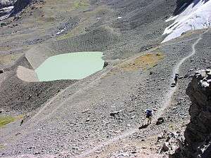 Schoolroom Glacier from Hurricane Pass | |
| Elevation | 10,338 ft (3,151 m)[1] |
| Traversed by |
Teton Crest Trail Cascade Canyon Trail |
| Location | Teton County, Wyoming, United States |
| Range |
Teton Range, Rocky Mountains |
| Coordinates | 43°43′42″N 110°51′03″W / 43.72833°N 110.85083°W[1] |
| Topo map | USGS Grand Teton, WY |
 | |
Hurricane Pass is a pedestrian mountain pass located in the Teton Range, Grand Teton National Park, in the U.S. state of Wyoming.[2] Situated at approximately 10,338 ft (3,151 m) above sea level, the pass can be accessed from the south by way of the Teton Crest Trail or from the north via the South Fork Cascade Canyon Trail. From Jenny Lake the roundtrip hike is 24.8 mi (39.9 km) with a 4,500 ft (1,400 m) elevation gain. Schoolroom Glacier is 100 yd (91 m) from the pass.[3] Views of the west slopes of several of the highest Teton Range peaks as well as Alaska Basin and Battleship Mountain in Caribou-Targhee National Forest are available at the pass.
References
- 1 2 "Hurricane Pass". Geographic Names Information System. United States Geological Survey. Retrieved 2012-02-18.
- ↑ Grand Teton, WY (Map). Topoquest (USGS Quads). Retrieved 2012-02-18.
- ↑ "Day Hikes" (pdf). National Park Service. March 2010. Retrieved 2012-02-18.
This article is issued from
Wikipedia.
The text is licensed under Creative Commons - Attribution - Sharealike.
Additional terms may apply for the media files.