Hurricane Norbert (1984)
| Category 4 major hurricane (SSHWS/NWS) | |
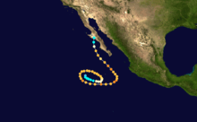
 Norbert on September 20 | |
| Formed | September 14, 1984 |
|---|---|
| Dissipated | September 28, 1984 |
| (Remnant low after September 26) | |
| Highest winds |
1-minute sustained: 130 mph (215 km/h) |
| Fatalities | None |
| Damage | Minimal |
| Areas affected | Baja California Sur, Sonora, Arizona |
| Part of the 1984 Pacific hurricane season | |
Hurricane Norbert marked the first time a core of a hurricane was fully mapped in three-dimensions. First forming on September 14, 1984 west of the Mexican coast, Norbert gradually intensified, reaching hurricane intensity two days after formation. On September 22, Norbert peaked in strength as a Category 4 hurricane on the Saffir-Simpson Hurricane Scale. While intensifying, Norbert meandered. It moved east, then north, then west, then south, then back towards the east, and finally towards the northeast. After fluctuating in intensity for two more days, Norbert rapidly weakened. It turned towards the northwest and made landfall in southern Baja California Norte as a tropical storm. The combination of Norbert and several other storms left thousands homeless throughout Mexico. The remnants of Hurricane Norbert produced moderate rain over Arizona.
Meteorological history
A tropical depression first developed on September 14 over the Pacific Ocean west of the Mexican coast. Six hours later, the depression intensified into Tropical Storm Norbert. Gradually strengthening, Norbert meandered in the weak steering currents for several days. The rate of intensification accelerated early on September 16, and shortly thereafter Norbert became a hurricane.[1]
On September 17, Norbert turned from the east to the north, and upon attaining Category 2 status on the Saffir–Simpson Hurricane Scale at 1800 UTC the next day, Norbert began to turn back to the west. Several hours later, Norbert was upgraded to a major hurricane (Category 3 or higher). While maintaining its intensity for two and a half days, Norbert then turned to the south and after slight strengthening, back to the east.[2] At 0000 UTC, September 21, Norbert reached its peak intensity of 130 mph (210 km/h). Meanwhile, a deep layer ridge over the Rocky Mountains was replaced by an upper-level trough, which extended south of Cabo San Lucas. This change in the steering patterns caused Hurricane Norbert to eventually turn to the northwest.[1]
Norbert fluctuated in intensity; six hours after its peak Norbert weakened back into a Category 3 hurricane, only to regain Category 4 strength on three separate occasions during the next 48 hours.[2] On September 23, a Hurricane Hunter aircraft was flown into Norbert and measured a 9.9 mi (15.9 km) eye and a closed eyewall.[1] On September 24, while located 300 mi (480 km) south-southwest of Cabo San Lucas, Norbert re-intensified into a Category 4 hurricane for the fourth time. Another aircraft reconnaissance flew into the hurricane[1] and observed that the heaviest precipitation was located east of the center of circulation.[3] It also had an asymmetrical wind field. Repeated penetrations were made into the eyewall, and scientists mapped the storm's three-dimensional (3-D) wind field. This marked the first time that the core of a hurricane was completely mapped in 3-D. The aircraft was also equipped with Doppler weather radar.[4]
Although the hurricane's motion accelerated, by 0000 UTC September 25, Norbert was only a mid-level Category 2 hurricane.[2] Later that day, the third and final Hurricane Hunter aircraft flew into Hurricane Norbert, finding a larger eye than the first flight, with a diameter of 16 mi (26 km).[1] After weakening back into a tropical storm early on September 26 [2], the system moved ashore near Point Abreojos in the central portion of the Baja California Peninsula as a high-end tropical storm. While the Monthly Weather Review suggests that the cyclone dissipated on September 27 over the peninsula,[1] it was last noted as a tropical depression over Arizona,[5] thus becoming one of the eight tropical cyclones to survive into the state.[6]
Preparations and impact
Hurricane Norbert was described as "big and ugly" by meteorologists. Planes were advised to use caution while navigating in the area. The Mazatlan government marine operator warned shipping to exercise extreme caution from Jalisco to Baja California Sur.[7] The Eastern Pacific Hurricane Center noted the possibility of heavy rains and flooding across portions of the Baja California Peninsula.[8] Throughout Mexico, a combination of Norbert and several other storms left many people without a home and hotels nearly empty.[9] Scattered and light rainfall fell across portions of Baja California Norte and Sonora, with rainfalls totals of 2.38 in (60 mm) and 2.44 in (62 mm) at Bento Juarez and Denchiva-San Pendro respectively. In all, rainfall data was reported at 284 locations across Mexico.[10] Upon entering Arizona, sustained winds of 20 to 30 mph (30 to 50 km/h) were recorded in the Tucson metropolitan area. Due to its rapid motion, only moderate rainfall occurred throughout south-central to northeast Arizona, with most locations reporting between 1 to 2 in (25 to 51 mm) of rain. However, Kitt Peak reported a 30-hour storm rainfall total of 4.15 in (105 mm). Lower than normal pressures were also recorded.[5] Across New Mexico, flash flood warnings were posted due to heavy rainfall.[11]
See also
References
- 1 2 3 4 5 6 Gunther, Emil B.; R.L. Cross (August 1985). "Eastern North Pacific Tropical Cyclones of 1984". Monthly Weather Review. 113 (8): 1393–1410. Bibcode:1985MWRv..113.1393G. doi:10.1175/1520-0493(1985)113<1393:ENPTCO>2.0.CO;2. ISSN 1520-0493.
- 1 2 3 4 National Hurricane Center; Hurricane Research Division; Central Pacific Hurricane Center. "The Northeast and North Central Pacific hurricane database 1949–2017". United States National Oceanic and Atmospheric Administration's National Weather Service. A guide on how to read the database is available here.
- ↑ Gamache, John F.; Houze, Robert A., Jr.; Marks, Frank D., Jr.; Houze; Marks (1993). "Dual-Aircraft Investigation of the inner Core of Hurricane Norbert. Part III: Water Budget". Journal of the Atmospheric Sciences. Journal of the Atmospheric Sciences, vol. 50, Issue 19, pp. 3221-3243; NASA. 50 (19): 3221. Bibcode:1993JAtS...50.3221G. doi:10.1175/1520-0469(1993)050<3221:DAIOTI>2.0.CO;2.
- ↑ Frank D. Marks; Rober A. Houze; John F. Gamache (September 9, 1991). "Dual-Aircraft Investigation of the inner Core of Hurricane Norbert. Part I: Kinematic Structure" (PDF). American Meteorological Society. Journal of the Atmospheric Sciences, vol. 49, Issue 191 pp.919-942. Retrieved September 11, 2011.
- 1 2 National Weather Service, Tucson Regional Office. "Hurricane Norbert 1984". Retrieved September 11, 2011.
- ↑ National Weather Service, Tucson Regional Office. "Tropical cyclones in Arizona". Retrieved October 11, 2011.
- ↑ "Hurricane big and ugly, shipping warned". September 24, 1984. Retrieved September 11, 2011.
- ↑ "Rain May Spatter Southland Today". L.A. Times. September 25, 1984.
- ↑ "Storm batters Mexico resort". The Spokes-Review. September 24, 1984. Retrieved September 11, 2011.
- ↑ "Hurricane Norbert – July 24–27, 1984". Hydrometeorological Prediction Center. Retrieved September 10, 2011.
- ↑ "Domestic News". Associated Press. 1984-09-26.
Tropical cyclones of the 1984 Pacific hurricane season | ||
|---|---|---|
 | ||
| ||