Ocean current
An ocean current is a continuous, directed movement of sea water generated by a number forces acting upon the water, including wind, the Coriolis effect, breaking waves, cabbeling, and temperature and salinity differences. Depth contours, shoreline configurations, and interactions with other currents influence a current's direction and strength. Ocean currents are primarily horizontal water movements.
Ocean currents flow for great distances, and together, create the global conveyor belt which plays a dominant role in determining the climate of many of the Earth’s regions. More specifically, ocean currents influence the temperature of the regions through which they travel. For example, warm currents traveling along more temperate coasts increase the temperature of the area by warming the sea breezes that blow over them. Perhaps the most striking example is the Gulf Stream, which makes northwest Europe much more temperate than any other region at the same latitude. Another example is Lima, Peru, where the climate is cooler, being sub-tropical, than the tropical latitudes in which the area is located, due to the effect of the Humboldt Current.
Function
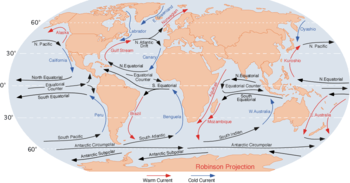
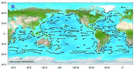
Surface oceanic currents are sometimes wind driven and develop their typical clockwise spirals in the northern hemisphere and counter-clockwise rotation in the southern hemisphere due to imposed wind stresses. In these wind-driven currents, the Ekman spiral effect results in the currents flowing at an angle to the driving winds. In addition, the areas of surface ocean currents move somewhat with the seasons; this is most notable in equatorial currents.
Deep ocean basins generally have a non-symmetric surface current, in that the eastern equatorward-flowing branch is broad and diffuse whereas the western poleward flowing branch is very narrow. These western boundary currents (of which the Gulf Stream is an example) are a consequence of the rotation of the Earth.
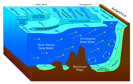
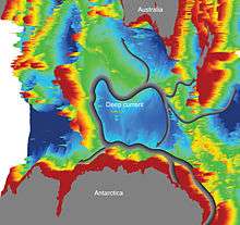
Deep ocean currents are driven by density and temperature gradients. Thermohaline circulation is also known as the ocean's conveyor belt (which refers to deep ocean density-driven ocean basin currents). These currents, called submarine rivers, flow under the surface of the ocean and are hidden from immediate detection. Where significant vertical movement of ocean currents is observed, this is known as upwelling and downwelling. Deep ocean currents are currently being researched using a fleet of underwater robots called Argo.
Surface currents make up only 8% of all water in the ocean, are generally restricted to the upper 400 m (1,300 ft) of ocean water, and are separated from lower regions by varying temperatures and salinity which affect the density of the water, which in turn, defines each oceanic region. Because the movement of deep water in ocean basins is caused by density-driven forces and gravity, deep waters sink into deep ocean basins at high latitudes where the temperatures are cold enough to cause the density to increase.
Ocean currents are measured in sverdrup (sv), where 1 sv is equivalent to a volume flow rate of 1,000,000 m3 (35,000,000 cu ft) per second.
Surface currents are found on the surface of an ocean, and are driven by large scale wind currents. They are directly affected by the wind—the Coriolis effect plays a role in their behaviours.[1]
Thermohaline circulation
The thermohaline circulation is a part of the large-scale ocean circulation that is driven by global density gradients created by surface heat and freshwater fluxes.[2][3] The adjective thermohaline derives from thermo- referring to temperature and -haline referring to salt content, factors which together determine the density of sea water. Wind-driven surface currents (such as the Gulf Stream) travel polewards from the equatorial Atlantic Ocean, cooling en route, and eventually sinking at high latitudes (forming North Atlantic Deep Water). This dense water then flows into the ocean basins. While the bulk of it upwells in the Southern Ocean, the oldest waters (with a transit time of around 1000 years)[4] upwell in the North Pacific.[5] Extensive mixing therefore takes place between the ocean basins, reducing differences between them and making the Earth's oceans a global system. On their journey, the water masses transport both energy (in the form of heat) and matter (solids, dissolved substances and gases) around the globe. As such, the state of the circulation has a large impact on the climate of the Earth. The thermohaline circulation is sometimes called the ocean conveyor belt, the great ocean conveyor, or the global conveyor belt. On occasion, it is imprecisely used to refer to the meridional overturning circulation, MOC.

Importance
3.png)
Knowledge of surface ocean currents is essential in reducing costs of shipping, since traveling with them reduces fuel costs. In the wind powered sailing-ship era, knowledge of wind patterns and ocean currents was even more essential. A good example of this is the Agulhas Current (down along eastern Africa), which long prevented Portuguese sailors from reaching India. In recent times, around-the-world sailing competitors make good use of surface currents to build and maintain speed. Ocean currents are also very important in the dispersal of many life forms. An example is the life-cycle of the European Eel.
Ocean currents are important in the study of marine debris, and vice versa. These currents also affect temperatures throughout the world. For example, the ocean current that brings warm water up the north Atlantic to northwest Europe also cumulatively and slowly blocks ice from forming along the seashores, which would also block ships from entering and exiting inland waterways and seaports, hence ocean currents play a decisive role in influencing the climates of regions through which they flow. Cold ocean water currents flowing from polar and sub-polar regions bring in a lot of plankton that are crucial to the continued survival of several key sea creature species in marine ecosystems. Since plankton are the food of fish, abundant fish populations often live where these currents prevail.
Ocean currents can also be used for marine power generation, with areas off of Japan, Florida and Hawaii being considered for test projects.
OSCAR: Near-realtime global ocean surface current data set
The OSCAR Near-realtime global ocean surface currents website describes the project and links to data validation and data downloads.
OSCAR data is used extensively in climate studies. maps and descriptions or annotations of climatic anomalies have been published in the monthly Climate Diagnostic Bulletin since 2001 and are routinely used to monitor ENSO and to test weather prediction models. OSCAR currents are routinely used to evaluate the surface currents in Global Circulation Models (GCMs), for example in NCEP Global Ocean Data Assimilation System (GODAS) and European Centre for Medium-Range Weather Forecasts (ECMWF).[6]
See also
References
- ↑ National Ocean Service (March 25, 2008). "Surface Ocean Currents". noaa.gov. National Oceanic and Atmospheric Administration. Archived from the original on July 6, 2017. Retrieved 2017-06-13.
- ↑ Rahmstorf, S (2003). "The concept of the thermohaline circulation" (PDF). Nature. 421 (6924): 699. Bibcode:2003Natur.421..699R. doi:10.1038/421699a. PMID 12610602.
- ↑ Lappo, SS (1984). "On reason of the northward heat advection across the Equator in the South Pacific and Atlantic ocean". Study of Ocean and Atmosphere Interaction Processes. Moscow Department of Gidrometeoizdat (in Mandarin): 125–9.
- ↑ The global ocean conveyor belt is a constantly moving system of deep-ocean circulation driven by temperature and salinity; What is the global ocean conveyor belt?
- ↑ Primeau, F (2005). "Characterizing transport between the surface mixed layer and the ocean interior with a forward and adjoint global ocean transport model". Journal of Physical Oceanography. 35 (4): 545–64. Bibcode:2005JPO....35..545P. doi:10.1175/JPO2699.1.
- ↑ Dohan, Kathleen; Lagerloef, Gary. "OSCAR—Ocean Surface Current Analyses Real-time". esr.org. Earth & Space Research. Archived from the original on 2017-12-28. Retrieved 2017-06-12.
- Hansen, B.; Østerhus, S; Quadfasel, D; Turrell, W (2004). "Already the day after tomorrow?". Science. 305 (5686): 953–954. doi:10.1126/science.1100085. PMID 15310882.
- Kerr, Richard A. (2004). "A slowing cog in the North Atlantic ocean's climate machine". Science. 304 (5669): 371–372. doi:10.1126/science.304.5669.371a. PMID 15087513.
- Munday, Phillip L.; Jones, Geoffrey P.; Pratchett, Morgan S.; Williams, Ashley J. (2008). "Climate change and the future for coral reef fishes". Fish and Fisheries. 9 (3): 261–285. doi:10.1111/j.1467-2979.2008.00281.x.
- Rahmstorf, S. (2003). "Thermohaline circulation: The current climate". Nature. 421 (6924): 699–699. Bibcode:2003Natur.421..699R. doi:10.1038/421699a. PMID 12610602.
- Roemmich, D. (2007). "Physical oceanography: Super spin in the southern seas". Nature. 449 (7158): 34–35. Bibcode:2007Natur.449...34R. doi:10.1038/449034a. PMID 17805284.
External links
| Wikimedia Commons has media related to Ocean currents. |
- RSMAS Ocean Surface Currents
- Coastal Ocean Current Monitoring Program
- Ocean Motion and Surface Currents
- Data Visualizer from OceanMotion.org
- ocean currents map