Hurricane, North Carolina
| Hurricane | |
|---|---|
| Unincorporated community | |
 Hurricane Location within the state of North Carolina | |
| Coordinates: 35°54′51″N 82°45′28″W / 35.91417°N 82.75778°WCoordinates: 35°54′51″N 82°45′28″W / 35.91417°N 82.75778°W | |
| Country | United States |
| State | North Carolina |
| County | Madison County |
| Elevation | 1,598 ft (487 m) |
| Time zone | UTC-5 (Eastern (EST)) |
| • Summer (DST) | UTC-4 (EDT) |
| ZIP code | 28743, 28753 |
| Area code(s) | 828 |
| GNIS feature ID | 1012294[1] |
Hurricane (variant name: Hurricane Church) is an unincorporated community in Madison County, North Carolina, United States. The community is named after Little Hurricane Creek, a tributary of Big Laurel Creek. Centered at the intersection of US 25/US 70 and NC 208. The community is part of the Asheville Metropolitan Statistical Area.
References
Municipalities and communities of Madison County, North Carolina, United States | ||
|---|---|---|
| Towns | 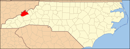 | |
| Unincorporated communities | ||
This article is issued from
Wikipedia.
The text is licensed under Creative Commons - Attribution - Sharealike.
Additional terms may apply for the media files.