Hünxe
| Hünxe | |||
|---|---|---|---|
| |||
 Hünxe Location of Hünxe within Wesel district 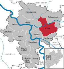  | |||
| Coordinates: 51°38′30″N 6°46′2″E / 51.64167°N 6.76722°ECoordinates: 51°38′30″N 6°46′2″E / 51.64167°N 6.76722°E | |||
| Country | Germany | ||
| State | North Rhine-Westphalia | ||
| Admin. region | Düsseldorf | ||
| District | Wesel | ||
| Government | |||
| • Mayor | Dirk Buschmann | ||
| Area | |||
| • Total | 106.8 km2 (41.2 sq mi) | ||
| Elevation | 35 m (115 ft) | ||
| Population (2016-12-31)[1] | |||
| • Total | 13,617 | ||
| • Density | 130/km2 (330/sq mi) | ||
| Time zone | CET/CEST (UTC+1/+2) | ||
| Postal codes | 46569 | ||
| Dialling codes | 02858, 02064, 0281, 02853, 02855, 02856 | ||
| Vehicle registration | WES | ||
| Website | www.huenxe.de | ||


Hünxe, church
Hünxe is a municipality in the district of Wesel, in North Rhine-Westphalia, Germany. It is part of the Rhine-Waal euroregion
Geography
Location
Hünxe is located approximately 10 km east of Wesel and 9 km north of Dinslaken. The neighbouring municipalities are: Schermbeck, Dorsten, Bottrop, Dinslaken, Voerde, Wesel und Hamminkeln. The most part of the municipality belongs to the natural park Hohe Mark. The river Lippe and the Wesel–Datteln Canal cross the municipality.
Area
The municipality of Hünxe spans over an area of 106,80 km². It is divided into the six subdivisions of Hünxe, Bruckhausen, Bucholtwelmen, Drevenack, Gartrop-Bühl and Krudenburg.
References
- ↑ "Amtliche Bevölkerungszahlen" (in German). Landesbetrieb Information und Technik NRW. Retrieved 2018-02-24.
Towns and municipalities in Wesel (district) | ||
|---|---|---|
| Authority control |
|---|
This article is issued from
Wikipedia.
The text is licensed under Creative Commons - Attribution - Sharealike.
Additional terms may apply for the media files.