Hungary–Romania border
| Hungary–Romania border | |
|---|---|
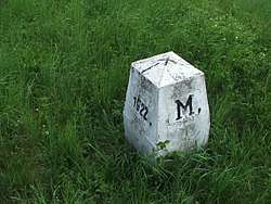 Border marker between Hungary and Romania at Csenger | |
| Characteristics | |
| Entities |
|
| Length | 448 kilometers |
| History | |
| Established | 1920 |
| Signing of the Treaty of Trianon at the end of the World War I | |
| Current shape | 1947 |
| Paris Peace Treaties | |
| Treaties |
Treaty of Trianon (1920) Second Vienna Award (1940) Paris Peace Treaties (1947) |
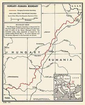
The Hungary–Romania border is the state border between Hungary and Romania.
History
It was established in 1920 by an international commission (the "Lord Commission") presided over by geographers such as Robert William Seton-Watson and Emmanuel de Martonne, and the historian Ernest Denis.[1]
Geography
The Hungarian–Romanian border begins at a tripoint located in the historical region of the Banat, 15 km south-east of the Hungarian town of Szeged, where the border between Hungary and Serbia intersects the land border between Romania and Serbia. It generally runs south-south-westwards/north-north-eastwards across the Pannonian Basin to another tripoint located on the Tur river, 16 km north of the Romanian town of Satu Mare, where the Hungarian-Ukrainian border intersects the land border between Romania and Ukraine.
Border crossings
Road
Rail
All railway crossings are standard gauge. As of June 2018, all railway crossings have passenger traffic.
- Curtici - Lőkösháza, electricified 25 kV 50Hz
- Salonta - Kötegyán
- Episcopia Bihor - Biharkeresztes
- Valea lui Mihai - Nyírábrány
- Carei - Tiborszállás
See also
References
| Wikimedia Commons has media related to Hungary-Romania border. |
- ↑ Lowczyk Olivier, La fabrique de la paix. Du Comité d'études à la Conférence de la paix, l'élaboration par la France des traités de la Première Guerre mondiale, Paris, Economica, Coll. Bibliothèque stratégique, 2010, 533p.