Hundar, Leh
| Hundar Hunder, Hundur | |
|---|---|
| village | |
 | |
 Hundar Location in Jammu and Kashmir, India  Hundar Hundar (India) | |
| Coordinates: 34°34′33″N 77°29′41″E / 34.575836°N 77.494823°ECoordinates: 34°34′33″N 77°29′41″E / 34.575836°N 77.494823°E | |
| Country | India |
| State | Jammu and Kashmir |
| District | Leh |
| Tehsil | Nubra |
| Population (2011) | |
| • Total | 1,179 |
| Time zone | UTC+5:30 (IST) |
| Census code | 928 |
Hundar is a village in the Leh district of Jammu and Kashmir, India famous for Sand dune, Bactrian camel.[1] It is located in the Nubra tehsil, on the bank of Shyok River. The Hunder Monastery is located here.
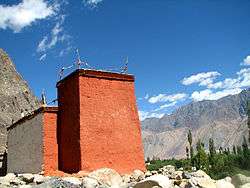
Hundar was once the capital of former Nubra kingdom. There are several ruined buildings, including the ruins of the King's palace, the Langchen Khar ("Elephant Palace"). There is a fort at the top of the hill, called Gula. Hundar also has two Buddhist temples: white temple (Lhakhang Karpo) and the red temple (Lhakhang Marpo).[2] Between Hundar and Diskit lie sand dunes.[3]
Demographics
According to the 2011 census of India, Hundar has 269 households. The effective literacy rate (i.e. the literacy rate of population excluding children aged 6 and below) is 60.65%.[4]
| Total | Male | Female | |
|---|---|---|---|
| Population | 1179 | 548 | 631 |
| Children aged below 6 years | 137 | 54 | 83 |
| Scheduled caste | 0 | 0 | 0 |
| Scheduled tribe | 1170 | 540 | 630 |
| Literates | 632 | 341 | 291 |
| Workers (all) | 728 | 341 | 387 |
| Main workers (total) | 267 | 169 | 98 |
| Main workers: Cultivators | 7 | 6 | 1 |
| Main workers: Agricultural labourers | 1 | 1 | 0 |
| Main workers: Household industry workers | 1 | 1 | 0 |
| Main workers: Other | 258 | 161 | 97 |
| Marginal workers (total) | 461 | 172 | 289 |
| Marginal workers: Cultivators | 410 | 143 | 267 |
| Marginal workers: Agricultural labourers | 23 | 6 | 17 |
| Marginal workers: Household industry workers | 1 | 0 | 1 |
| Marginal workers: Others | 27 | 23 | 4 |
| Non-workers | 451 | 207 | 244 |
References
| Wikimedia Commons has media related to Hunder Village. |
- ↑ "Blockwise Village Amenity Directory" (PDF). Ladakh Autonomous Hill Development Council. Retrieved 2015-07-23.
- ↑ Prem Singh Jina (1997). Recent Researches on the Himalaya. Indus. pp. 32–. ISBN 978-81-7387-069-9.
- ↑ Max Lovell-Hoare; Sophie Lovell-Hoare (1 July 2014). Kashmir: Jammu. Kashmir Valley. Ladakh. Zanskar. Bradt Travel Guides. pp. 113–. ISBN 978-1-84162-396-2.
- 1 2 "Leh district census". 2011 Census of India. Directorate of Census Operations. Retrieved 2015-07-23.