Hughes River (Virginia)
| Hughes River | |
|---|---|
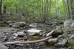 Headwaters scene in Madison County | |
| Country | United States |
| Physical characteristics | |
| Main source | Virginia |
The Hughes River is a 14.0-mile-long (22.5 km)[1] river in Madison, Rappahannock, and Culpeper counties in the U.S. state of Virginia. The river rises on the east slope of Stony Man mountain in Shenandoah National Park and flows southeast past the village of Nethers to join the Hazel River west of Boston, Virginia. Via the Hazel River and the Rappahannock River, the Hughes River is part of the Chesapeake Bay watershed.
See also
References
- ↑ U.S. Geological Survey. National Hydrography Dataset high-resolution flowline data. The National Map Archived 2012-04-05 at WebCite, accessed April 1, 2011
- U.S. Geological Survey Geographic Names Information System: Hughes River
- USGS Hydrologic Unit Map - State of Virginia (1974)
- Salmon, Emily J.; Campbell, Jr., Edward D. C. (1994). The Hornbook of Virginia History (4th ed.). Richmond, VA: Virginia Office of Graphic Communications. ISBN 0-88490-177-7.
Coordinates: 38°31′25″N 78°10′11″W / 38.52374°N 78.16972°W
This article is issued from
Wikipedia.
The text is licensed under Creative Commons - Attribution - Sharealike.
Additional terms may apply for the media files.