Huamanripayco (Canchis)
| Huamanripayco | |
|---|---|
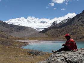 Chumpe as seen from Sibinacocha. The western slope of Huamanripayco is visible on the right side of this image. | |
| Highest point | |
| Elevation | 5,200 m (17,100 ft) [1] |
| Coordinates | 13°47′39″S 71°03′21″W / 13.79417°S 71.05583°WCoordinates: 13°47′39″S 71°03′21″W / 13.79417°S 71.05583°W |
| Geography | |
 Huamanripayco Peru | |
| Location | Peru, Cusco Region |
| Parent range | Andes, Vilcanota |
Huamanripayco (possibly from Quechua wamanripa Senecio, -yuq a suffix,[2][3][4] "the one with the wamanripa") is a mountain in the Vilcanota mountain range in the Andes of Peru, about 5,200 m (17,100 ft) high. It is located in the Cusco Region, Canchis Province, Pitumarca District. Huamanripayco lies on the northeastern shore of Sibinacocha.[1]
References
- 1 2 escale.minedu.gob.pe - UGEL map of the Quispicanchi Province 1 (Cusco Region)
- ↑ Louis Girault: Kallawaya - guérisseurs itinérants des Andes. Recherches sur les pratiques médicinales et magiques. Paris 1984. p. 89 (kkana), 91, 467 (wamanripa)
- ↑ Primer Curso Nacional de Plantas Medicinales y Fitoterapia: FITO 2001, 06-12 agosto del 2001, conferencias y mesas redondas. Instituto de Fitoterapia Americano, 2001. p. 16. huamanripa: Senecio tephrosioides, Senecio vulgaris
- ↑ Teofilo Laime Ajacopa, Diccionario Bilingüe Iskay simipi yuyayk'ancha, La Paz, 2007 (Quechua-Spanish dictionary)
This article is issued from
Wikipedia.
The text is licensed under Creative Commons - Attribution - Sharealike.
Additional terms may apply for the media files.