Hreðavatn
| Hreðavatn | |
|---|---|
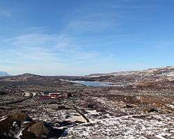 Bifröst seen from the Grábrók craters, the lake is to the right side in the background | |
| Coordinates | 64°45′N 21°36′W / 64.750°N 21.600°WCoordinates: 64°45′N 21°36′W / 64.750°N 21.600°W |
| Basin countries | Iceland |
| Max. length | 5 km (3.1 mi) |
| Surface area | 1.14 km2 (0.44 sq mi) |
| Max. depth | 20 m (66 ft) |
| Surface elevation | 56 m (184 ft) |
Hreðavatn is a lake in the west of Iceland. It is situated near Route 1 (the Ring Road) between Borgarnes and the pass of Holtavörtuheiði. Nearby is the university faculty of Bifröst and the Grábrók craters as well as the mountain Baula.
The surface of the lake is 1.14 km², it lies 56 m above sea level, its length is about 5 km and its greatest depth 20 m. It is embedded in a scenic landscape of heath and small forest plantations.
See also
External links
- https://web.archive.org/web/20040529132132/http://www.nat.is/nateng/hredavatn.htm
- https://web.archive.org/web/20040620053013/http://iww.is/pages/xw/wl.html (w.Photo)
This article is issued from
Wikipedia.
The text is licensed under Creative Commons - Attribution - Sharealike.
Additional terms may apply for the media files.