Hrabušice
| Hrabušice | |
| Village | |
 | |
| Country | Slovakia |
|---|---|
| Region | Košice |
| District | Spišská Nová Ves |
| Elevation | 548 m (1,798 ft) |
| Coordinates | 48°59′N 20°25′E / 48.983°N 20.417°ECoordinates: 48°59′N 20°25′E / 48.983°N 20.417°E |
| Area | 40.9 km2 (15.8 sq mi) |
| Population | 2,255 (2005-12-31) |
| Density | 55/km2 (142/sq mi) |
| First mentioned | 1279 |
| Postal code | 053 15 |
| Area code | +421-53 |
| Car plate | SN |
  Location of Hrabušice in Slovakia | |
 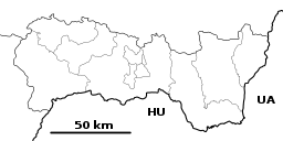 Location of Hrabušice in the Košice Region | |
| Statistics: MOŠ/MIS | |
| Website: www.hrabusice.sk | |
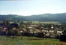
Hrabušice is a village and municipality in the Spišská Nová Ves District in the Košice Region of central-eastern Slovakia. Hrabušice is the starting point for the walks through Slovak karst region. Tourism is a major local employer here.
History
The village was first mentioned in local records in 1279. It contains the 13th century Church of St. Laurence, and the ruins of a Carthusian monastery, built about 1305 on the site of a refuge used during the period of the Tatar invasions.
Geography
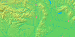
The village lies at an altitude of 548 metres and covers an area of 40.886 km². In 2011 Hrabušice had a population of about 2,378 inhabittants.
Genealogical resources
The records for genealogical research are available at the state archive "Statny Archiv in Levoca, Slovakia"
- Roman Catholic church records (births/marriages/deaths): 1703-1903 (parish A)
- Lutheran church records (births/marriages/deaths): 1788-1910 (parish B)
See also
External links
| Authority control |
|---|
This article is issued from
Wikipedia.
The text is licensed under Creative Commons - Attribution - Sharealike.
Additional terms may apply for the media files.