Howardsville, Colorado
| Howardsville | |
|---|---|
| Unincorporated community | |
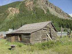 An old cabin at Howardsville | |
 Howardsville Location within the state of Colorado | |
| Coordinates: 37°50′8″N 107°35′39″W / 37.83556°N 107.59417°WCoordinates: 37°50′8″N 107°35′39″W / 37.83556°N 107.59417°W | |
| Country | United States |
| State | Colorado |
| County | San Juan |
| Elevation | 9,747 ft (2,971 m) |
| Time zone | UTC-7 (Mountain (MST)) |
| • Summer (DST) | UTC-6 (MDT) |
| GNIS feature ID | 187646[1] |
Howardsville is an unincorporated community in San Juan County, Colorado, United States, along the Animas River at the mouth of Cunningham Creek. Its elevation is 9,747 feet (2,971 m).
Established and laid out by the Bullion City Company as Bullion City in 1874, it was renamed later in the year, either for Lieutenant Howard, a once-prominent local figure, or for George Howard, who once had a cabin in the area. It was the first county seat of San Juan County, holding that title until 1875.[1]
References
- 1 2 "Howardsville, Colorado". Geographic Names Information System. United States Geological Survey. Retrieved 2008-01-09.
External links
Municipalities and communities of San Juan County, Colorado, United States | ||
|---|---|---|
| Town | 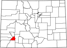 | |
| Unincorporated communities | ||
| Ghost towns | ||
This article is issued from
Wikipedia.
The text is licensed under Creative Commons - Attribution - Sharealike.
Additional terms may apply for the media files.