Horta-Guinardó
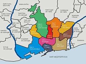
Horta-Guinardó (Catalan pronunciation: [ˈɔɾtə ɣinəɾˈðo]) is the name of one of the districts of Barcelona, located in its North-Eastern corner. It is named after two very heterogeneous areas of the city, Horta and el Guinardó, which together cover a large area of 11.92 km², which sums up for the 11,9% of the total extension of the city.
A former municipality that eventually became part of the city in the late 19th century, it is bordered by five out of ten districts of Barcelona (Gràcia, Nou Barris, Eixample, Sant Andreu and Sant Martí), and by two other municipalities of the metropolitan area (Sant Cugat and Cerdanyola del Vallès). It didn't undergo a massive urbanisation process until the 1950s.
Territory and demographics
Its inhabitants added up to 169,920 in the 2005 census. As the third largest district in the city (after Sants-Montjuïc and Sarrià-Sant Gervasi), it is not one of the most densely populated parts of the city: the figures show its population is actually in decline. It is known for the steepness of its streets, which is due to the hilly landscape in this area of Barcelona, surrounded by the hills of Collserola, Vall d'Hebron and Riera d'Horta.
Neighbourhoods
See also
External links
| Wikimedia Commons has media related to Horta-Guinardó District. |