Subtropical ridge
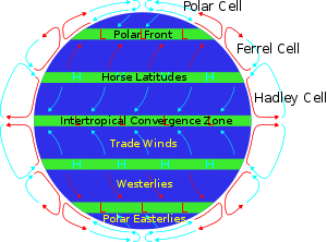
The subtropical ridge, also known as the subtropical high or horse latitudes, is a significant belt of atmospheric high pressure situated around the latitudes of 30°N in the Northern Hemisphere and 30°S in the Southern Hemisphere. It is the product of the global air circulation cell known as the Hadley Cell. The subtropical ridge is characterized by mostly calm winds, which act to reduce air quality under its axis by causing fog overnight, and haze during daylight hours as a result of the stable atmosphere found near its location. The air descending from the upper troposphere flows out from its center at surface level toward the upper and lower latitudes of each hemisphere, creating both the trade winds and the westerlies. The subtropical ridge moves poleward during the summer, reaching its most northern latitude in early fall, before moving equatorward during the cold season. The El Niño southern climate oscillation (ENSO) can displace the northern hemisphere subtropical ridge, with La Niñas allowing for a more northerly axis for the ridge, while El Niños show flatter, more southerly ridges. The change of the ridge position during ENSO cycles changes the tracks of tropical cyclones that form around their equatorward and western peripheries. As the subtropical ridge varies in position and strength, it can enhance or depress monsoon regimes around their low-latitude periphery.
Formation
Heating of the earth near the equator leads to large amounts of convection along the monsoon trough or Intertropical convergence zone. This air mass rises to the lower stratosphere where it diverges, moving away from the equator in the upper troposphere in both northerly and southerly directions. As it moves towards the mid-latitudes on both sides of the equator, the air cools and sinks. The resulting air mass subsidence creates a subtropical ridge of high pressure near the 30th parallel in both hemispheres. At the surface level, the sinking air diverges again with some returning to the equator, completing the Hadley circulation. This circulation on each side of the equator is known as the Hadley cell and leads to the formation of the subtropical ridge.[1] Many of the world's deserts are caused by these climatological high-pressure areas.
Migration

The subtropical ridge starts migrating poleward in late spring reaching its zenith in early autumn before retreating equatorward during the late fall, winter, and early spring. The equatorward migration of the subtropical ridge during the cold season is due to increasing north-south temperature differences between the poles and tropics.[2] The latitudinal movement of the subtropical ridge is strongly correlated with the progression of the monsoon trough or Intertropical Convergence Zone.
Most tropical cyclones form on the side of the subtropical ridge closer to the equator, then move poleward past the ridge axis before recurving into the main belt of the Westerlies.[3] When the subtropical ridge shifts due to ENSO, so will the preferred tropical cyclone tracks. Areas west of Japan and Korea tend to experience many fewer September–November tropical cyclone impacts during El Niño and neutral years, while mainland China experiences much greater landfall frequency during La Niña years. During El Niño years, the break in the subtropical ridge tends to lie near 130°E, which would favor the Japanese archipelago, while in La Niña years the formation of tropical cyclones, along with the subtropical ridge position, shift west, which increases the threat to China.[4] In the Atlantic basin, the subtropical ridge position tends to lie about 5 degrees farther south during El Niño years, which leads to a more southerly recurvature for tropical cyclones during those years.
When the Atlantic Multidecadal Oscillation's mode is favorable to tropical cyclone development (1995–present), it amplifies the subtropical ridge across the central and eastern Atlantic.[5]
Role in weather formation and air quality

When the subtropical ridge in the northwest Pacific is stronger than normal, it leads to a wet monsoon season for Asia.[6] The subtropical ridge position is linked to how far northward monsoon moisture and thunderstorms extend into the United States. The subtropical ridge across North America typically migrates far enough northward to begin monsoon conditions across the Desert Southwest from July to September.[7] When the subtropical ridge is farther north than normal towards the Four Corners, monsoon thunderstorms can spread northward into Arizona. When the high pressure moves south, its circulation cuts off the moisture and the atmosphere dries out across the Desert Southwest, causing a break in the monsoon regime.[8]
On the subtropical ridges western edge (eastern coast of continents), the high pressure cell creates a southerly flow of tropical air toward the lower east sides of continents in the summer months. In the United States the subtropical ridge Bermuda High helps create the hot, sultry summers with daily thunderstorms typical of the Gulf and Atlantic states. This flow pattern also occurs on the eastern coasts of continents in other subtropical climates such as South China, southern Japan, central-eastern South America, southern Queensland and KwaZulu Natal province in South Africa.[9]
When surface winds become light, the subsidence produced directly under the subtropical ridge can lead to a buildup of particulates in urban areas under the ridge, leading to widespread haze.[10] If the low level relative humidity rises towards 100 percent overnight, fog can form.[11]
References
- ↑ Dr. Owen E. Thompson (1996). Hadley Circulation Cell. Archived 2009-03-05 at the Wayback Machine. Channel Video Productions. Retrieved on 2007-02-11.
- ↑ Roger Graham Barry, Richard J. Chorley (1992). Atmosphere, weather, and climate. Routledge. p. 117. ISBN 978-0-415-07760-6. Retrieved 2009-11-09.
- ↑ Joint Typhoon Warning Center (2006). 3.3 JTWC Forecasting Philosophies. United States Navy. Retrieved on 2007-02-11.
- ↑ M. C. Wu, W. L. Chang, and W. M. Leung (2003). Impacts of El Nino-Southern Oscillation Events on Tropical Cyclone Landfalling Activity in the Western North Pacific. Journal of Climate: pp. 1419–1428. Retrieved on 2007-02-11.
- ↑ Dr. Gerald Bell, Dr. Muthuvel Chelliah, Dr. Kingste Mo, Stanley Goldenberg, Dr. Christopher Landsea, Eric Blake, Dr. Richard Pasch (2004). NOAA: 2004 Atlantic Hurricane Outlook. Climate Prediction Center. Retrieved on 2007-02-11.
- ↑ C.-P. Chang, Yongsheng Zhang, and Tim Li (1999). Interannual and Interdecadal Variations of the East Asian Summer Monsoon and Tropical Pacific SSTs. Part I: Roles of the Subtropical Ridge. Journal of Climate: pp. 4310–4325. Retrieved on 2007-02-11.
- ↑ Arizona State University (2009). Basics of the Arizona Monsoon & Desert Meteorology. Archived 2009-05-31 at the Wayback Machine. Retrieved on 2007-02-11.
- ↑ David K. Adams (2009). Review of Variability in the North American Monsoon. United States Geological Survey. Retrieved on 2007-02-11.
- ↑ Adelson, Glen; Environment: An Interdisciplinary Anthology, pp. 466-467 ISBN 0300110774
- ↑ Myanmar government (2007). Haze. Archived 2008-02-24 at the Wayback Machine. Retrieved on 2007-02-11.
- ↑ Robert Tardif (2002). Fog characteristics. Archived 2011-05-20 at the Wayback Machine. University Corporation for Atmospheric Research. Retrieved on 2007-02-11.