Horní Lhota (Ostrava-City District)
| Horní Lhota | |||
|---|---|---|---|
| Village | |||
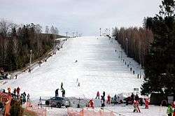 Vaňkův kopec ski slope | |||
| |||
 Location in the Czech Republic | |||
| Coordinates: 49°48′29″N 18°04′07″E / 49.80806°N 18.06861°ECoordinates: 49°48′29″N 18°04′07″E / 49.80806°N 18.06861°E | |||
| Country | Czech Republic | ||
| Region | Moravian-Silesian | ||
| District | Ostrava-City | ||
| Area | |||
| • Total | 4.84 km2 (1.87 sq mi) | ||
| Elevation | 377 m (1,237 ft) | ||
| Population (2014) | |||
| • Total | 803[1] | ||
| Postal code | 747 64 | ||
| Website |
www | ||
_CoA.jpg)
Horní Lhota is a village in Ostrava-City District, Moravian-Silesian Region, Czech Republic.
References
This article is issued from
Wikipedia.
The text is licensed under Creative Commons - Attribution - Sharealike.
Additional terms may apply for the media files.