Hope Airport (Alaska)
| Hope Airport | |||||||||||
|---|---|---|---|---|---|---|---|---|---|---|---|
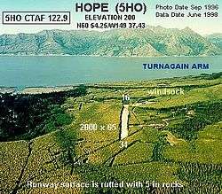 Aerial view of airport from the south, 1996 | |||||||||||
| Summary | |||||||||||
| Airport type | Public | ||||||||||
| Owner | Alaska DOT&PF - Central Region | ||||||||||
| Serves | Hope, Alaska | ||||||||||
| Elevation AMSL | 200 ft / 61 m | ||||||||||
| Coordinates | 60°54′15″N 149°37′26″W / 60.90417°N 149.62389°W | ||||||||||
| Runways | |||||||||||
| |||||||||||
| Statistics (2011) | |||||||||||
| |||||||||||
Hope Airport (FAA LID: 5HO) is a state owned, public-use airport located one nautical mile (2 km) southeast of the central business district of Hope,[1] in the Kenai Peninsula Borough of the U.S. state of Alaska. This airport is included in the FAA's National Plan of Integrated Airport Systems for 2011–2015, which categorized it as a general aviation facility.[2]
Facilities and aircraft
Hope Airport covers an area of 62 acres (25 ha) at an elevation of 200 feet (61 m) above mean sea level. It has one runway designated 16/34 with a gravel surface measuring 2,000 by 90 feet (610 x 27 m). For the 12-month period ending May 31, 2011, the airport had 480 aircraft operations, an average of 40 per month: 90% general aviation and 10% air taxi.[1]
References
- 1 2 3 FAA Airport Master Record for 5HO (Form 5010 PDF). Federal Aviation Administration. effective 25 August 2011.
- ↑ National Plan of Integrated Airport Systems for 2011–2015: Appendix A (PDF, 2.03 MB) Archived 2012-09-27 at the Wayback Machine.. Federal Aviation Administration. Updated 4 October 2010.
External links
- "FAA Alaska airport diagram". FAA, Alaska Region. 19 February 2004. Archived from the original (GIF) on 14 January 2009.
- Aerial image as of 3 September 1996 from USGS The National Map
- Resources for this airport:
- FAA airport information for 5HO
- AirNav airport information for 5HO
- FlightAware airport information and live flight tracker
- SkyVector aeronautical chart for 5HO
This article is issued from
Wikipedia.
The text is licensed under Creative Commons - Attribution - Sharealike.
Additional terms may apply for the media files.