Honeysuckle Creek Tracking Station
Honeysuckle Creek tracking station was a NASA Earth station in Australia near Canberra,[1] which played an important role in supporting Project Apollo. The station was opened in 1967 and closed in 1981.[2]
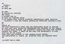
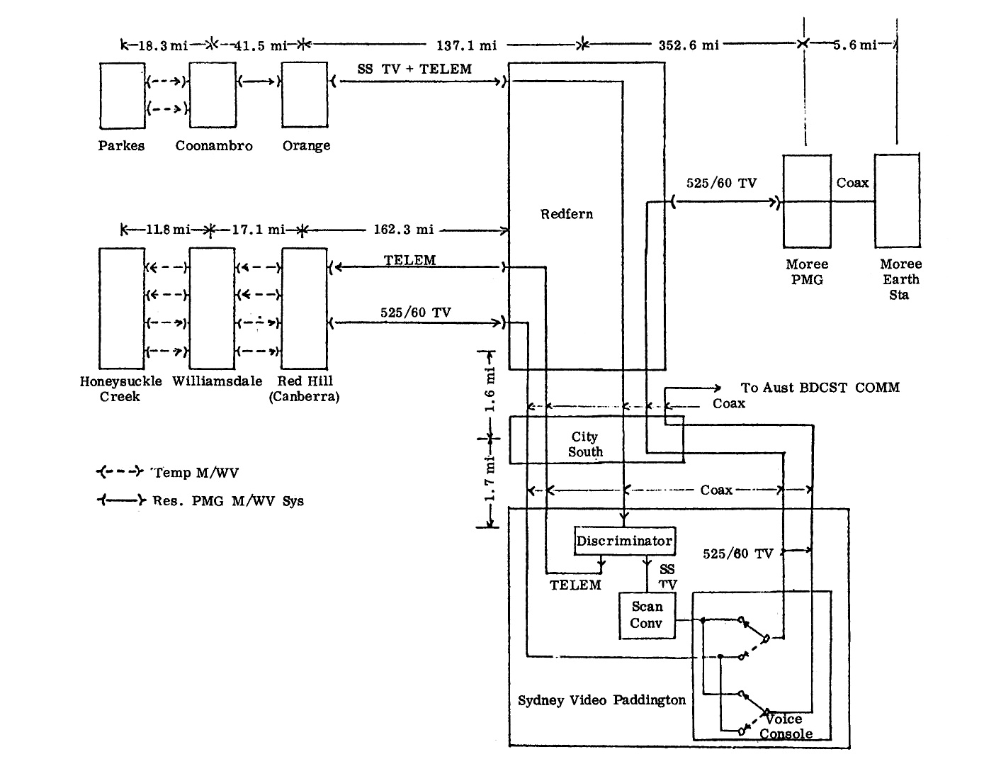
The Honeysuckle Creek station, a 26 meter dish and now decommissioned, is most famous for being the antenna which received and relayed to the world the first historic TV images of astronaut Neil Armstrong setting foot on the Moon on 21 July 1969. Apart from the television pictures they provided, Honeysuckle Creek and Tidbinbilla had voice and telemetry contact with the lunar and command modules. Much of this was dramatized in the 2000 Australian film The Dish. Unlike what the film depicted, Parkes only received the landing footage and footage from inside the command and lunar modules, despite strong winds at the time, but due to the wind issues at Parkes, the images from Armstrong's first moonwalk came from the Honeysuckle Creek antenna. Both the Canberra Deep Space Communications Complex and Honeysuckle antenna's were built and run by NASA, but Parkes was built and run by the CSIRO, which partially funded the film. The CSIRO, a government body, did not embellish the truth slightly, the director and producer of the film did that. The images that came from Honeysuckle were sent direct to OTC Sydney via Williamdale and Red Hill (Canberra)[3] where NASA's Charlie Goodman selected the best picture from Honeysuckle Creek or Parkes to send to NASA for broadcast to the world.
After the conclusion of the Apollo Moon missions in 1972, Honeysuckle Creek began supporting regular Skylab passes, the Apollo scientific stations left on the Moon by astronauts, and assisting the Deep Space Network with interplanetary tracking commitments.
In 1974 at the conclusion of the Skylab program, Honeysuckle Creek joined the Deep Space Network as Deep Space Station 44. Honeysuckle Creek closed in December 1981, its 26 m antenna being relocated to the Canberra Deep Space Communications Complex at nearby Tidbinbilla, and renamed Deep Space station 46, where it remained in use until late 2009. In May 2010 the American Institute of Aeronautics and Astronautics declared the antenna a Historical Aerospace Site, so the antenna will remain in place at the CDSCC, in perpetuity, as a historical site.[4]
Today the original site has been leveled, and only the concrete foundations remain. An outdoor display was added to the site in 2001.
The original site is considered to be the geographical centre of the Australian Capital Territory.[5]
See also
External links
References
- ↑ https://www.google.com.au/maps/place/Historical+Site+of+the+Honeysuckle+Creek+Tracking+Station+used+for+NASA+Apollo+missions/@-35.581846,149.0171162,17z/data=!3m1!4b1!4m15!1m7!3m6!1s0x6b17d1a42e77c249:0x13c19a6e444e33b2!2sHoneysuckle+Creek!3b1!8m2!3d-35.5767011!4d148.9948082!3m6!1s0x0:0xb7b929a5cd5a534e!8m2!3d-35.581851!4d149.0193057!9m1!1b1
- ↑ Mackellar, Colin (10 April 2010). "A Tribute to Honeysuckle Creek Tracking Station". Retrieved 23 April 2010.
- ↑ https://www.honeysucklecreek.net/images/Apollo_11/A11_Aust_signal_path.jpg
- ↑ "AustraliaHistoricalSite" (PDF). American Institute of Aeronautics and Astronautics. Archived from the original (PDF) on 11 July 2010. Retrieved 18 July 2010.
- ↑ http://www.ga.gov.au/scientific-topics/national-location-information/dimensions/centre-of-australia-states-territories#heading-8
Coordinates: 35°35′02″S 148°58′37″E / 35.5838°S 148.9769°E