Centre points of Australia
Centre points of Australia are those geographical locations that have been considered to be centre of Australia,[1] as distinct from the extreme points of Australia.
Finding the centre point
John McDouall Stuart wrote "Sunday, 22 April 1860, Small Gum Creek, under Mount Stuart, Centre of Australia - today I find from my observations of the sun, 111° 00' 30", that I am now camped in the centre of Australia. I have marked a tree and planted the British flag there."[2][3][4]
Below are five methods which have been used to locate the centre point of Australia:
Centre of gravity method
- 23 degrees 7 minutes south latitude, 132 degrees 8 minutes east longitude (23°07′S 132°08′E / 23.117°S 132.133°E); position on SF53-13 Hermannsburg 1:250 000 and 5351 Glen Helen 1:100 000 scale maps.[5]
Furthest point from the coastline
- 23 degrees 2 minutes south latitude, 132 degrees 10 minutes east longitude (23°02′S 132°10′E / 23.033°S 132.167°E); position on SF53-13 Hermannsburg 1:250 000 and 5351 Glen Helen 1:100 000 scale maps.[6]
Median point
The median point was calculated as the midpoint between the extremes of latitude and longitude of the continent.
- 24 degrees 15 minutes south latitude, 133 degrees 25 minutes east longitude (24°15′S 133°25′E / 24.250°S 133.417°E); position on SG53-01 Henbury 1:250 000 and 5549 James 1:100 000 scale maps.
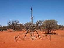
Lambert Gravitational Centre
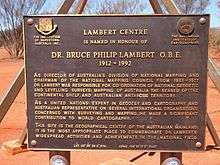
In 1988 the Royal Geographical Society of Australasia determined the geographical centre of Australia as a Bicentennial project. A monument was erected to mark the location and named in honour of Dr. Bruce Philip Lambert, a former Director of the Division of National Mapping, for his achievements in the national survey, levelling and mapping of the continent.[7] Similar to the centre of gravity method, the location was calculated from 24,500 points at the high-water mark of Australia's coastline.[8][9] The computed result of the 1988 project was:
- 25 degrees 36 minutes 36.4 seconds south latitude, 134 degrees 21 minutes 17.3 seconds east longitude (25°36′36.4″S 134°21′17.3″E / 25.610111°S 134.354806°E); position on SG53-06 Finke 1:250 000 and 5746 Beddome 1:100 000 scale maps.[10][11]
- Dr. Cecil Madigan studied Central Australian geology in the 1930s. He calculated the centre of gravity by using a metal cut-out of Australia with a plumb bob and string, and selected a point less than 11 kilometres due west of this present position.[12][13]
Johnston Geodetic Station
This trigonometric survey cairn, situated about one kilometre north of Mt Cavenagh Homestead, was built by officers of the Division of National Mapping in 1965, and was once the central reference point for all Australian surveys. It was named after Fredrick Marshall Johnston, former Commonwealth Surveyor General and the first Director of National Mapping. Today, surveys are based on the Geocentric Datum of Australia (GDA), a new and more accurate Australian coordinate system which has replaced the Australian Geodetic Datum (AGD) of which the Johnston station is a major part. Further information on datum types and their applications is available from the geodesy pages, or from the Inter-governmental Committee on Surveying & Mapping (ICSM).
- 25° 56' 49.3" South, 133° 12' 34.7" East; position on SG53-05 Kulgera 1:250 000 and 5546 Kulgera 1:100 000 scale maps.
Centre of population
Australia has not seen its population centroid move drastically since the creation of the country. In 1911, the centroid was in central New South Wales; in 1996, it was only slightly further northwest.[14]
Centre of the Australian States
Just as there are various ways to calculate the centre of Australia as a whole there are various methods of calculating the centre of the states. However, the Government body responsible for determining such matters, Geoscience Australia, has adopted the following locations as the official centroid for each of the States.[15]
- The Geographic Centre of New South Wales centre is located just off Cockies Road, 33 km west-north-west of Tottenham 110 km west of Dubbo.[16] (32° 09' 48" South, 147° 01' 00" East)
- The Geographical Centre of Queensland, is located 17 km north-west of Muttaburra. (22° 29' 13" South, 144° 25' 54" East)
- The Geographic Centre of South Australia is 12 km north-east of the Mount Eba cattle station south-west of Lake Eyre. (30° 03' 30" South, 135° 45' 48" East)
- The Geographic Centre of Tasmania is found on the western shore of Little Pine Lagoon. (42° 01' 17" South, 146° 35' 36" East)[17]
- The Geographic Centre of Victoria is located around 10 km south-south-east of Bendigo, on the steps of the Mandurang Uniting Church. (36° 51' 15" South, 144° 16' 52" East)
- The Geographic Centre of Western Australia is in the Gascoyne Region. (25° 19' 41" South, 122° 17' 54" East)
Centre of the Australian Territories
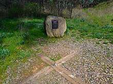
- The Geographic Centre of the Australian Capital Territory is at the former site of the Honeysuckle Creek Tracking Station. (35° 29' 24" South, 149° 00' 05" East)
- The Geographic Centre of the Northern Territory is approximately 91 km west-north-west of Tennant Creek. (19° 23' 00" South, 133° 21' 28" East)
See also
- Central Australia - about the region - rather than the geographical point
- List of extreme points of Australia
References
- ↑ http://www.ga.gov.au/education/geoscience-basics/dimensions/centre-of-australia-states-territories.html#fivecentres
- ↑ T. Flannery (ed.), The Explorers, The Text Publishing Company, Melbourne, 1998.
- ↑ 25°36'36"S 134°21'17"E (Lambert Gravitational Centre) Lambert Gravitational Centre
- ↑ Works by John McDouall Stuart at Project Gutenberg
- ↑ Centre of Australia at Geoscience Australia webpage.
- ↑ http://www.ga.gov.au/education/geoscience-basics/dimensions/centre-of-australia-states-territories.html#fivecentres
- ↑ http://www.waymarking.com/waymarks/WMY40
- ↑ http://www.travelblog.org/Oceania/Australia/South-Australia/Marla/blog-458718.html
- ↑ Lee Atkinson, Real middle Australia SMH June 22, 2013.
- ↑ http://www.ga.gov.au/education/geoscience-basics/dimensions/centre-of-australia-states-territories.html#fivecentres
- ↑ "Archived copy". Archived from the original on 12 March 2011. Retrieved 2010-01-01.
- ↑ see also his bio in ADB online - http://adbonline.anu.edu.au/biogs/A100367b.htm
- ↑ http://www.cntraveler.com/daily-traveler/2012/02/australia-center-lambert-gravitational-monumen-maphead-ken-jennings
- ↑ "Figure 15: Shifts in the Australian Population Centroid*, 1911–1996". Parliament of Australia Parliamentary Library. Archived from the original on 19 August 2000. Retrieved 7 January 2009.
- ↑ Geoscience Australia
- ↑ Geoscience Australia
- ↑ http://www.ga.gov.au/scientific-topics/national-location-information/dimensions/centre-of-australia-states-territories#heading-13