Holy Island, Anglesey
| Native name: Ynys Gybi | |
|---|---|
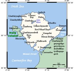 A map showing the Isle of Anglesey and Holy Island | |
 Holy Island | |
| Geography | |
| Location | Irish Sea |
| Coordinates | 53°17′N 4°37′W / 53.283°N 4.617°WCoordinates: 53°17′N 4°37′W / 53.283°N 4.617°W |
| Archipelago | British Isles |
| Area | 15.22 sq mi (39.4 km2) |
| Length | 12.3 km (7.64 mi) |
| Width | 5.6 km (3.48 mi) |
| Highest elevation | 220 m (720 ft) |
| Highest point | Holyhead Mountain |
| Administration | |
|
Wales | |
| County | Isle of Anglesey |
| Largest settlement | Holyhead (pop. 11,237) |
| Demographics | |
| Population | 13,659 (2011) |
| Pop. density | 346 /km2 (896 /sq mi) |
| Ethnic groups | Welsh people |
Holy Island (Welsh: Ynys Gybi, 'the island of (Saint) Cybi') is an island (15.22 sq mi (39.4 km2)) on the western side of the larger Isle of Anglesey, Wales, from which it is separated by a narrow, winding channel. It is called "Holy" because of the high concentration of standing stones, burial chambers, and other religious sites on the small island. The alternative and historic name of the island is Holyhead Island. According to the 2011 UK Census, the population was 13,659, of which 11,431 (84%) lived in the largest town, Holyhead.
History

Irish pirates invaded Anglesey following the end of Roman rule in Britannia. Cunedda first began warfare against the Irish but ultimately Cadwallon Lawhir defeated the Irish on Holy Island.
Natural features
There are a variety of natural habitats on Anglesey including mudflats, dunes, marshes, and beaches.[1] Practically nothing is left of the oak forest that covered almost all of the island before the arrival of Neolithic farmers.[2] The western side of the island is taken up mainly by Holyhead Mountain, an area of maritime heather moor, which is the highest peak in the county at 722 feet (220 m). The coastal zone between the island and the mainland of Anglesey is a large site of special scientific interest – Beddmanarch–Cymyran.
Transport

Holy Island is connected to Anglesey by two road links. The first, the Stanley Embankment, is made up of causeways carrying the A5/A55 and the main railway line to Chester and London, and the original bridge of the A5 post road. The second is Four Mile Bridge, which carries a 'B' road and is much smaller.
The main settlement is the port of Holyhead, from which passenger ferries travel to Dublin Port, Ireland, and freight ferries also travel to Dublin. Holyhead railway station is located in the town. Other settlements include the villages of Trearddur Bay, Rhoscolyn, and Four Mile Bridge.
Around 30 miles (48 km) of the 125-mile (201 km) Anglesey Coastal Path is on Holy Island.
Shipwrecks
Peripheral islands and stacks include North Stack, and South Stack, with its famous lighthouse. Before – and even after – the construction of lighthouses, the cliffs and jagged rocks of the island were a great danger to sailors.