Holwierde
| Holwierde | |
|---|---|
| Village | |
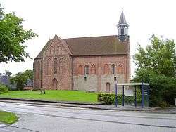 Stefanuskerk (Stephen Church) | |
 Holwierde Location in the province of Groningen in the Netherlands | |
| Coordinates: 53°21′N 6°52′E / 53.350°N 6.867°ECoordinates: 53°21′N 6°52′E / 53.350°N 6.867°E | |
| Country | Netherlands |
| Province | Groningen |
| Municipality | Delfzijl |
| Area (2012)[1] | |
| • Total | 101 ha (250 acres) |
| • Land | 100 ha (200 acres) |
| • Water | 1 ha (2 acres) |
| Population (2017)[1] | |
| • Total | 960 |
| • Density | 950/km2 (2,500/sq mi) |
| Time zone | UTC+1 (CET) |
| • Summer (DST) | UTC+2 (CEST) |
| Postal code | 9905 PA – 9905 TL[2] |
| Area code(s) | 0596[3] |
Holwierde (Dutch pronunciation: [ˈɦɔlʋirdə]; Gronings: Holwier) is a village in the municipality of Delfzijl in the province of Groningen in the Netherlands. It lies about 26 km northeast of the city of Groningen.
In 2001, the town of Holwierde had 813 inhabitants. The built-up area of the town was 0.27 km², and contained 323 residences.[4]
The statistical area "Holwierde", which also can include the peripheral parts of the village, as well as the surrounding countryside, has a population of around 960.[5]
References
- 1 2 (in Dutch) "Holwierde", Kerncijfers wijken en buurten 2009-2012, Statistics Netherlands, 2014. Retrieved on 12 April 2015.
- ↑ (in Dutch) Zoekresultaten, Postcode.nl. Retrieved on 12 April 2015.
- ↑ (in Dutch) Netnummer 0596 Holwierde, Netnummer.info. Retrieved on 12 April 2015.
- ↑ Statistics Netherlands (CBS), Bevolkingskernen in Nederland 2001 Archived 2006-03-19 at the Wayback Machine.. (Statistics are for the continuous built-up area).
- ↑ Statistics Netherlands (CBS), Kerncijfers wijken en buurten 2017.
External links

This article is issued from
Wikipedia.
The text is licensed under Creative Commons - Attribution - Sharealike.
Additional terms may apply for the media files.