Hollywood Hills
| Hollywood Hills | |
|---|---|
| Neighborhood of Los Angeles | |
 The Hollywood Hills and the Hollywood Sign | |
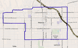 Map of the Hollywood neighborhood of Los Angeles, as delineated by the Los Angeles Times | |
| Country |
|
| State |
|
| City | Los Angeles |
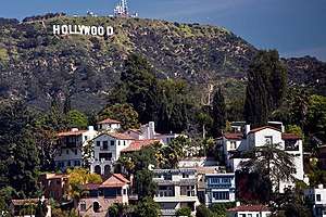
The Hollywood Hills are a part of the Santa Monica Mountains and also a hillside neighborhood of the same name in the central region of the city of Los Angeles, California.
Geography
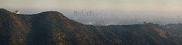

The Hollywood Hills are a part of the Santa Monica Mountains.
The neighborhood touches Studio City, Universal City and Burbank on the north, Griffith Park on the north and east, Los Feliz on the southeast, Hollywood on the south and Hollywood Hills West on the west. It includes Forest Lawn Memorial Park, the Hollywood Reservoir, the Hollywood Sign, the Hollywood Bowl and the John Anson Ford Theater.[1][2][3][4]
Hollywood Hills is bisected southeast-northwest by US 101. The neighborhood is bounded on the northwest and north by the Los Angeles city line, on the east by a fireroad through Griffith Park, continuing on Western Avenue, on the south by Franklin Avenue and on the west by an irregular line that includes Outpost Drive.[4][5]
Adjacent neighborhoods
Relation of the Hollywood Hills to nearby areas (not necessarily continuous):[4]
 |
Universal City | Burbank | Burbank |
| |||
| Hollywood Hills West | Griffith Park | ||||||
| Hollywood Hills West | Hollywood | Los Feliz, Los Angeles |
Neighborhood
The neighborhood of Hollywood Hills includes the Hollywood Bowl and Forest Lawn Memorial Park (Hollywood Hills) as well as two private and three public schools.
Hollywood Hills contains several neighborhoods:[5]
- Laurel Canyon
- Beachwood Canyon
- Cahuenga Pass
- Franklin Village
- Hollywood Dell
- Hollywood Heights
- Hollywoodland
- Outpost Estates
- Whitley Heights
Population
A total of 21,588 people lived in the neighborhood's 7.05 square miles, according to the 2000 U.S. census—averaging 3,063 people per square mile, among the lowest population densities in the city or the county. The population was estimated at 22,988 in 2008. The median age for residents was 37, considered old for the city and the county. The percentages of residents aged 19 through 64 were among the county's highest.[5]
The neighborhood is "not particularly diverse" for the city, the diversity index being 0.433, and the percentage of white people is considered high, at 74.1%. Latinos make up 9.4%, Asians are at 6.7%, African American at 4.6% and others at 5.3%. In 2000, Mexico (7.9%) and the United Kingdom (7.8%) were the most common places of birth for the 22.8% of the residents who were born abroad, which was considered a low percentage of foreign-born when compared with the city or county as a whole.[6]
The median household income in 2008 dollars was $69,277, considered high for the city but about average for the county. The percentage of households earning $125,000 or more was high, compared to the county at large. The average household size of 1.8 people was relatively low. Renters occupied 56.5% of the housing units, and homeowners the rest.[5]
In 2000, there were 270 families headed by single parents, or 6.9%, a rate that was low in both the county and the city.[5]
Education
In 2000, 54.8% of residents aged 25 and older held a four-year degree, considered high when compared with the city and the county as a whole.[5]
There are five secondary or elementary schools within the neighborhood's boundaries:[7]
- Immaculate Heart High and Middle School, private, 5515 Franklin Avenue
- Valley View Elementary School, LAUSD, 6921 Woodrow Wilson Drive
- The Neilson Academy, private, 2528 Canyon Drive
- Cheremoya Avenue Elementary School, LAUSD, 6017 Franklin Avenue
- The Oaks, private elementary, 6817 Franklin Avenue
The American Film Institute is at 2021 North Western Avenue[8]
Recreation and culture
The neighborhood includes:[4]
- The Hollywood Bowl
- The John Anson Ford Amphitheatre
- A portion of Griffith Park, including Hollywoodland Camp
- Forest Lawn Memorial Park
Notable residents
- Ben Affleck, actor
- Christina Aguilera, singer
- Earle D. Baker (1888–1969), Los Angeles City Council member[9][10][11][12]
- Halle Berry, actress
- Jolene Blalock, actress[13]
- Gisele Bundchen, Victoria's Secret supermodel, bought her three-bedroom house in the Hollywood Hills for close to $2 million
- Sam Cooke (1931-1964), singer[14]
- Kevin Costner, actor
- Robert Culp (1930-2010), actor[15]
- Richard Dreyfuss, actor
- Anna Faris, actress [16]
- Errol Flynn (1909-1959), actor[17]
- Stuart Hamblen (1908-1989), country singer[18]
- Salma Hayek, actress
- Niall Horan, Irish pop singer[19]
- Helen Hunt, actress
- Billy Idol, English rock musician[20]
- Tom Leykis, radio and internet talk show personality[21]
- Demi Lovato, actress, singer and songwriter
- Tobey Maguire paid more than $2 million for a modern home in the Hollywood Hills
- Johnny Mathis, singer[22]
- Joel McHale, American actor and comedian[23]
- Simon Monjack (1970-2010), director, producer, writer[24]
- Brittany Murphy (1977-2009), actress[24]
- Kristin Nelson, actress and painter[25]
- Ricky Nelson (1940-1985), actor, singer and songwriter[25]
- Tracy Nelson, actress[25]
- Matthew Perry, actor[26]
- Joaquin Phoenix, actor[27]
- Chris Pratt, actor,[16]
- Keanu Reeves actor, bought a house in May 2003 for $4.5 million
- Kevin Smith, actor, director and comedian[28]
- Sage Stallone (1976-2012), actor and son of Sylvester Stallone[29][30]
- Robert and Peggy Stevenson, Los Angeles City Council members[31][32]
- Quentin Tarantino, film director[33]
- Justin Timberlake, American singer, songwriter, actor and record producer
- Anna Kendrick, actress, singer
- Rebel Wilson, actress, comedian and singer[34]
See also
- Lloyd G. Davies, Los Angeles City Council member, 1943–51, active against gravel extraction in the hills
References
- ↑ "Central L.A.," Mapping L.A., Los Angeles Times
- ↑ "Hollywood," Mapping L.A., Los Angeles Times
- ↑ "San Fernando Valley," Mapping L.A., Los Angeles Times
- 1 2 3 4 The Thomas Guide, 2006, pages 563 and 593
- 1 2 3 4 5 6 "Hollywood Hills," Mapping L.A., Los Angeles Times
- ↑ "Diversity," Mapping L.A., Los Angeles Times
- ↑ "Hollywood Hills Schools," Mapping L.A., Los Angeles Times
- ↑ Mapping L.A., Los Angeles Times
- ↑ "Services Slated for Ex-Councilman Baker," Los Angeles Times, July 17, 1969, page B-4
- ↑ Fairfield Avenue residence of the Baker family on Mapping L.A.
- ↑ Los Angeles Public Library reference file
- ↑ Odin Street residence of the Baker family on Mapping L.A.
- ↑ Variety
- ↑ MacDonald, Les (July 8, 2010). The Day the Music Died. Xlibris Corporation. ISBN 9781469113562.
- ↑ McLellan, Dennis (March 25, 2010). "Robert Culp dies at 79; actor starred in 'I Spy' TV series". Los Angeles Times.
- 1 2 Zillow.com
- ↑ "On Former Errol Flynn Estate, a House for $7.9 Million". Wall Street Journal. ISSN 0099-9660. Retrieved January 1, 2016.
- ↑ "Stuart Hamblen Biography". www.paladincom.com. Retrieved January 1, 2016.
- ↑ "Niall Horan Drops $4 Million on a New Hollywood Hills Home". Retrieved August 6, 2016.
- ↑ HILBURN, ROBERT (April 29, 1990). "Billy Idol: Pop's Rebel With a Cause : The feisty rock star fidgets after a motorcycle mishap puts his crucial music and movie plans on hold". Los Angeles Times. ISSN 0458-3035. Retrieved January 6, 2016.
- ↑ "The Tom Leykis Show".
- ↑ "Hollywood Hills home of singer Johnny Mathis damaged in fire". latimes.com. Retrieved January 9, 2016.
- ↑ "'Flipping Out's' Ryan Brown settles down in Los Feliz". latimes.
- 1 2 "Brittany Murphy's Mother Lists Hollywood Hills House". Variety. Retrieved January 1, 2016.
- 1 2 3 "Welcome Friends and Lovers of Hollywood - Home". www.lauriejacobson.com. Retrieved January 1, 2016.
- ↑ "Los Angeles Real Estate: Matthew Perry House In Hollywood Hills Sells For $4.69 Million (PHOTOS)". Huffington Post. February 20, 2013.
- ↑ Cristin Zweig (April 24, 2013). "Joaquin Phoenix Buys His Next Door Neighbor's House for $1.39 Million". Trulia. Retrieved March 29, 2015.
- ↑ "Writer and Director Kevin Smith lives in this Mansion". StarMap.
- ↑ Wilson, Simone (July 13, 2012). "Sage Stallone, Sylvester Stallone's Son, Found Dead in Hollywood Hills Apartment: Report". LAWeekly.
- ↑ Smith, Emily; Mohr, Ian (July 14, 2012). "Sylvester Stallone's son found dead; cause of death believed to be pill overdose". New York Post.
- ↑ Los Angeles Public Library reference file
- ↑ Los Angeles Public Library File (scroll to bottom)
- ↑ "Quentin Tarantino's 'Hateful Eight' premieres without police protest". Chicago Tribune.
- ↑ "Rebel Wilson Nabs Chandelier-Filled House in Hollywood Hills". Variety. Retrieved January 9, 2016.
External links
| By topic |  | |
|---|---|---|
| Government | ||
| Districts and neighborhoods | 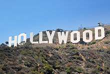 | |
|---|---|---|
| Points of interest | ||
| Neighboring cities and communities | ||