Cahuenga Pass
| Cahuenga Pass | |
|---|---|
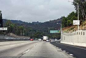 Northbound US Route 101/Hollywood Freeway entering the Cahuenga Pass | |
| Elevation | 745 ft (227 m) |
| Traversed by |
|
| Location | Los Angeles, California, United States |
| Range | Santa Monica Mountains |
The Cahuenga Pass (/kəˈwɛŋɡə/ (![]()
The Cahuenga Pass connects the Los Angeles Basin to the San Fernando Valley via U.S. Route 101 (Hollywood Freeway) and Cahuenga Boulevard. It is the lowest pass through the mountains.
It was the site of two major battles: the Battle of Cahuenga Pass in 1831 (a fight between local settlers and the Mexican-appointed governor and his men; two deaths), and the Battle of Providencia or Second Battle of Cahuenga Pass in 1845 (between locals over whether to secede from Mexico; one horse and one mule killed).[1] Both were on the San Fernando Valley side near present-day Studio City, and cannonballs are still occasionally found during excavations in the area.[2] Along the route of the historic El Camino Real, the historic significance of the pass is also marked by a marker along Cahuenga Blvd. which names the area Paseo de Cahuenga.
See also
- Campo de Cahuenga
- Rancho Cahuenga
- Cahuenga, California; Tongva settlement.
References
- ↑ "Landmark Events in L.A.'s Minority History". The University of Southern California. Archived from the original on 1999-04-28. Retrieved 2012-05-12.
- ↑ "The Second Battle of Cahuenga Pass and the War Lords of Burbank". Retrieved 2012-05-12.
External links
![]()
Places adjacent to Cahuenga Pass | |
|---|---|
| By topic |  | |
|---|---|---|
| Government | ||
| Districts and neighborhoods |  | |
|---|---|---|
| Points of interest | ||
| Neighboring cities and communities | ||
Coordinates: 34°07′28″N 118°20′34″W / 34.12446°N 118.34286°W