Hollymead, Virginia
| Hollymead | |
|---|---|
| Census-designated place | |
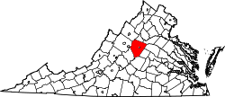
 Hollymead Location within the Commonwealth of Virginia  Hollymead Hollymead (the US) | |
| Coordinates: 38°07′01″N 78°26′30″W / 38.11694°N 78.44167°WCoordinates: 38°07′01″N 78°26′30″W / 38.11694°N 78.44167°W | |
| Country | United States |
| State | Virginia |
| County | Albemarle |
| Population (2010) | |
| • Total | 7,690 |
| Time zone | UTC−5 (Eastern (EST)) |
| • Summer (DST) | UTC−4 (EDT) |
| GNIS feature ID | 2584858[1] |
Hollymead is a census-designated place (CDP) in Albemarle County, Virginia, United States.[1] The population as of the 2010 Census was 7,690. It is located about seven miles north of Charlottesville, near Charlottesville-Albemarle Airport.
References
- 1 2 "Hollymead Census Designated Place". Geographic Names Information System. United States Geological Survey. Retrieved August 13, 2013.
This article is issued from
Wikipedia.
The text is licensed under Creative Commons - Attribution - Sharealike.
Additional terms may apply for the media files.