Hollis, Arkansas
| Hollis, Arkansas | |
|---|---|
| Unincorporated community | |
 | |
 Hollis  Hollis | |
| Coordinates: 34°52′28″N 93°06′38″W / 34.87444°N 93.11056°WCoordinates: 34°52′28″N 93°06′38″W / 34.87444°N 93.11056°W | |
| Country | United States |
| State | Arkansas |
| County | Perry |
| Elevation | 495 ft (151 m) |
| Time zone | UTC-6 (Central (CST)) |
| • Summer (DST) | UTC-5 (CDT) |
| Area code(s) | 501 |
| GNIS feature ID | 72045[1] |
Hollis is an unincorporated community in Perry County, Arkansas, United States. The community is located at the junction of Arkansas Highway 7 and Arkansas Highway 314, 20 miles (32 km) west-southwest of Perryville.[2]
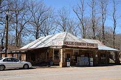
The Hollis Country Store and the South Fourche LaFave River Bridge, which are listed on the National Register of Historic Places, are in the community.[3]
References
- ↑ "Hollis". Geographic Names Information System. United States Geological Survey.
- ↑ Perry County, Arkansas General Highway Map (PDF) (Map). Arkansas State Highway and Transportation Department. January 4, 2008. Retrieved April 17, 2016.
- ↑ National Park Service (2010-07-09). "National Register Information System". National Register of Historic Places. National Park Service.
Municipalities and communities of Perry County, Arkansas, United States | ||
|---|---|---|
| City | 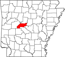 | |
| Towns | ||
| Unincorporated communities | ||
| Footnotes | ‡This populated place also has portions in an adjacent county or counties | |
This article is issued from
Wikipedia.
The text is licensed under Creative Commons - Attribution - Sharealike.
Additional terms may apply for the media files.