Hohenbrunn
| Hohenbrunn | ||
|---|---|---|
| ||
 Hohenbrunn Location of Hohenbrunn within Munich district 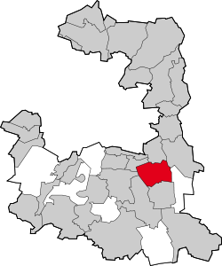 | ||
| Coordinates: 48°3′N 11°42′E / 48.050°N 11.700°ECoordinates: 48°3′N 11°42′E / 48.050°N 11.700°E | ||
| Country | Germany | |
| State | Bavaria | |
| Admin. region | Upper Bavaria | |
| District | Munich | |
| Government | ||
| • Mayor | Stefan Straßmair (CSU) | |
| Area | ||
| • Total | 16.82 km2 (6.49 sq mi) | |
| Elevation | 568 m (1,864 ft) | |
| Population (2017-12-31)[1] | ||
| • Total | 8,888 | |
| • Density | 530/km2 (1,400/sq mi) | |
| Time zone | CET/CEST (UTC+1/+2) | |
| Postal codes | 85662, 85521 | |
| Dialling codes | 08102, 089 | |
| Vehicle registration | M | |
| Website | www.hohenbrunn.de | |

Hohenbrunn is a municipality in the district of Munich in Bavaria, Germany.
It is located in the southeast of Munich, occupying an area of 16.82 km². It connects to the Bundesautobahn 99 with its own exit, BAS Hohenbrunn. As of 30 June 2014, the population was 8,726.
History
Early settlements existed around springs from 500 to 800 AD. The first written remark about Hohenbrunn is dated to the year 780 AD by Tassilo III of Bavaria.
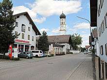
Hohenbrun, churchtower in the street
External links
- http://www.hohenbrunn.de Hohenbrunn Website (in German)
- https://www.verwaltungsservice.bayern.de Maintenance Bavaria Website (in German)
- ↑ "Fortschreibung des Bevölkerungsstandes". Bayerisches Landesamt für Statistik und Datenverarbeitung (in German). September 2018.
This article is issued from
Wikipedia.
The text is licensed under Creative Commons - Attribution - Sharealike.
Additional terms may apply for the media files.