Hoggestabben Butte
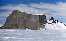
Hoggestabben Butte, view in southeast direction
Hoggestabben Butte (72°0′S 3°58′E / 72.000°S 3.967°ECoordinates: 72°0′S 3°58′E / 72.000°S 3.967°E) is a prominent butte, 2,410 metres (7,900 ft) high, standing 3 nautical miles (6 km) north of Mount Hochlin and being its highest northern outlier, in the Mühlig-Hofmann Mountains of Queen Maud Land, Antarctica. It was mapped by Norwegian cartographers from surveys and air photos by the Sixth Norwegian Antarctic Expedition (1956–60) and named Hoggestabben (the chopping block).[1]
References
- ↑ "Hoggestabben Butte". Geographic Names Information System. United States Geological Survey. Retrieved 2012-06-20.
![]()
This article is issued from
Wikipedia.
The text is licensed under Creative Commons - Attribution - Sharealike.
Additional terms may apply for the media files.