Hockessin, Delaware
| Hockessin, Delaware | |
|---|---|
| CDP | |
 | |
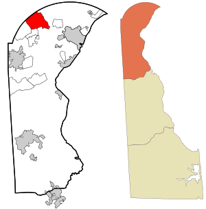 Location in New Castle County and the state of Delaware. | |
 Hockessin Location within the state of Delaware  Hockessin Hockessin (the US) | |
| Coordinates: 39°47′15″N 75°41′48″W / 39.78750°N 75.69667°WCoordinates: 39°47′15″N 75°41′48″W / 39.78750°N 75.69667°W | |
| Country | United States |
| State | Delaware |
| County | New Castle |
| Area | |
| • Total | 10.0 sq mi (26.0 km2) |
| • Land | 10.0 sq mi (26.0 km2) |
| • Water | 0.0 sq mi (0.0 km2) |
| Elevation | 259 ft (79 m) |
| Population (2010) | |
| • Total | 13,527 |
| • Density | 1,352.7/sq mi (520.3/km2) |
| Time zone | UTC-5 (Eastern (EST)) |
| • Summer (DST) | UTC-4 (EDT) |
| ZIP code | 19707 |
| Area code(s) | 302 |
| FIPS code | 10-35850 |
| GNIS feature ID | 214099[1] |
Hockessin /ˈhoʊkɛsɪn/ is a census-designated place (CDP) in New Castle County, Delaware, United States. The population was 13,527 at the 2010 census. The place name may be derived from the Lenape word "hòkèsa" meaning "pieces of bark" or from a misspelling of "occasion," as pronounced by the Quakers who settled the area originally.
History
Hockessin traces its roots to 1688.
The first Roman Catholic church in Delaware was located in Hockessin. Missionary priests from Maryland established the Coffee Run Mission in 1790.[2]
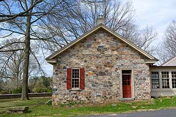
The A. Armstrong Farm, Coffee Run Mission Site, Hockessin Friends Meetinghouse, T. Pierson Farm, Public School No. 29, Springer Farm, and Wilmington and Western Railroad are listed on the National Register of Historic Places in 1978.[3]
Geography
According to the United States Census Bureau, the CDP has a total area of 10.0 square miles (26 km2), of which, 10.0 square miles (26 km2) of it is land and 0.10% is water.
Demographics
| Historical population | |||
|---|---|---|---|
| Census | Pop. | %± | |
| 1990 | 10,051 | — | |
| 2000 | 12,902 | 28.4% | |
| 2010 | 13,527 | 4.8% | |
| source:[4] | |||
As of the census[5] of 2000, there were 12,902 people, 4,464 households, and 3,731 families residing in the CDP. The population density was 1,286.7 people per square mile (496.7/km²). There were 4,575 housing units at an average density of 456.3 per square mile (176.1/km²). The racial makeup of the CDP was 88.82% White, 2.65% African American, 0.07% Native American, 7.16% Asian, 0.01% Pacific Islander, 0.45% from other races, and 0.84% from two or more races. Hispanic or Latino of any race were 1.99% of the population. From 1990 to 2016, the population of Hockessin has grown by about 35%.[6]
There were 4,464 households out of which 40.1% had children under the age of 18 living with them, 77.3% were married couples living together, 4.5% had a female householder with no husband present, and 16.4% were non-families. 13.9% of all households were made up of individuals and 8.9% had someone living alone who was 65 years of age or older. The average household size was 2.83 and the average family size was 3.13.
In the CDP, the population was spread out with 26.9% under the age of 18, 4.7% from 18 to 24, 24.5% from 25 to 44, 28.7% from 45 to 64, and 15.3% who were 65 years of age or older. The median age was 42 years. For every 100 females, there were 95.6 males. For every 100 females age 18 and over, there were 91.9 males.
The median income for a household in the CDP was $100,844, and the median income for a family was $108,784. Males had a median income of $76,617 versus $46,988 for females. The per capita income for the CDP was $40,516. About 1.0% of families and 1.7% of the population were below the poverty line, including 2.0% of those under age 18 and 1.3% of those age 65 or over.
Economy
Although Hockessin is primarily a bedroom community, there are several mushroom farms operating in the area.
Hockessin contains the Lantana Square Shopping Center[7], and the Hockessin Athletic Club[8], which contains a pool, indoor gym, and walking trail.
Arts and culture
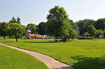
Hockessin hosts several Fourth of July activities for the area residents. Local groups parade down Old Lancaster Pike, neighborhoods compete in different athletic events, and there is a fireworks display in the evening in Swift Park.
Education
Hockessin is served by the Red Clay Consolidated School District for public education. Elementary schools serving Hockessin for grades K through 5 include Cooke Elementary School and North Star Elementary School.[9] Public school students in grades 6 through 8 attend Henry B. duPont Middle School.[10] Students in grades 9 through 12 in Hockessin attend Thomas McKean High School to the south of Hockessin or Alexis I. duPont High School in Greenville, with students in the western part of Hockessin attending John Dickinson High School in Pike Creek.[11][12][13] Private schools in Hockessin include CACC (Chinese American Community Center) Montessori School, Hockessin Montessori School, Sanford School, and Wilmington Christian School.
Infrastructure
Transportation
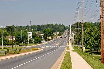
The main road through Hockessin is Delaware Route 41 (Lancaster Pike) which heads southeast toward Wilmington and northwest toward the Pennsylvania border, where it becomes Pennsylvania Route 41 and continues toward Lancaster. South of Hockessin, Delaware Route 48 splits from DE 41 to follow Lancaster Pike to Wilmington while DE 41 continues along Newport Gap Pike to Prices Corner. Delaware Route 7 passes through the western part of Hockessin along Limestone Road, heading north to the Pennsylvania border and south toward Pike Creek and Christiana. The northern terminus of the Wilmington and Western Railroad, a tourist railroad, is in Hockessin; the railroad follows the Red Clay Creek valley south to Greenbank.[14] DART First State provides bus service to Hockessin along Route 20, which follows Lancaster Pike to Wilmington and ends at the Wilmington station served by Amtrak and SEPTA Regional Rail's Wilmington/Newark Line. DART First State's Route 20 bus serves park and ride lots located at Hockessin Memorial Hall and the Wells Fargo bank.[15]
Notable people
- Cab Calloway, jazz singer and bandleader
- Matt Denn, Lieutenant Governor of Delaware
- Trevon Duval, basketball player for the Duke Blue Devils
- Tony Graffanino, Major League Baseball player
- Bernard Hopkins, professional boxer
- Kent A. Jordan, Federal Judge on the United States Court of Appeals for the Third Circuit
In popular culture
In Episode 210 of 30 Rock, two characters agree to meet halfway between New York City and Washington, DC, which they claim to be the mining town of "Hockassin," Pennsylvania. In reality, Hockessin is almost exactly equidistant between the two cities, and shares a border with Pennsylvania, but is not on a major transportation route running in that direction.
References
- ↑ "Hockessin". Geographic Names Information System. United States Geological Survey.
- ↑ Mertz, Ann Morris (September 25, 1986). "Pioneer Catholic church nears 200th anniversary". Brandywine Crossroads. Wilmington, DE. Retrieved 26 April 2010.
- ↑ National Park Service (2010-07-09). "National Register Information System". National Register of Historic Places. National Park Service.
- ↑ "CENSUS OF POPULATION AND HOUSING (1790-2000)". U.S. Census Bureau. Retrieved 2012-05-20.
- ↑ "American FactFinder". United States Census Bureau. Retrieved 2008-01-31.
- ↑ "Sperling's Best Places: Hockessin, Delaware".
- ↑ Team, The Untappd. "Lantana Square Shopping Center". Untappd. Retrieved 2018-08-02.
- ↑ "Hockessin Athletic Club". Hockessin Athletic Club. Retrieved 2018-08-02.
- ↑ "Approved 2015-16 Elementary Attendance Zones" (PDF). Red Clay Consolidated School District. Retrieved March 25, 2018.
- ↑ "Henry B. duPont Middle School Attendance Zone" (PDF). Red Clay Consolidated School District. Retrieved March 12, 2018.
- ↑ "Thomas McKean High School Attendance Zone" (PDF). Red Clay Consolidated School District. Retrieved March 12, 2018.
- ↑ "Alexis I. duPont High School Attendance Zone" (PDF). Red Clay Consolidated School District. Retrieved March 12, 2018.
- ↑ "John Dickinson High School Attendance Zone" (PDF). Red Clay Consolidated School District. Retrieved March 12, 2018.
- ↑ Delaware Department of Transportation (2008). Delaware Official Transportation Map (PDF) (Map). Dover: Delaware Department of Transportation.
- ↑ "Routes and Schedules". DART First State. Retrieved August 16, 2013.
External links
| Wikivoyage has a travel guide for Hockessin. |