Hochfirst (Ötztal Alps)
| Hochfirst | |
|---|---|
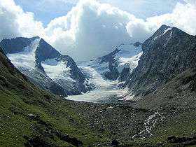 Hochfirst (left) and Liebenerspitze (right of center) separated by the Gaisbergferner as seen from the north. | |
| Highest point | |
| Elevation | 3,405 m (11,171 ft) |
| Prominence | 393 m (1,289 ft) |
| Parent peak | Hinterer Seelenkogel |
| Coordinates | 46°49′36″N 11°04′52″E / 46.82667°N 11.08111°ECoordinates: 46°49′36″N 11°04′52″E / 46.82667°N 11.08111°E |
| Geography | |
 Hochfirst Location within Austria on the Austrian—Italian border | |
| Location | Tyrol, Austria / South Tyrol, Italy |
| Parent range | Ötztal Alps |
| Climbing | |
| First ascent | 15 July 1870 by J. Scholz and J. Gärber guided by Peter Paul Gstrein and Blasis Grüner |
The Hochfirst or Hoher First (Italian: Monte Principe) is a mountain in the main chain (Gurgler Kamm or "Gurgl Ridge") of the Ötztal Alps.
This article is issued from
Wikipedia.
The text is licensed under Creative Commons - Attribution - Sharealike.
Additional terms may apply for the media files.