Hlíðar
| Hlíðar | |
|---|---|
| District | |
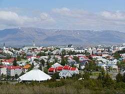 Skyline of Hlíðar | |
.png) | |
| Coordinates: 64°08′04″N 21°55′08″W / 64.13444°N 21.91889°WCoordinates: 64°08′04″N 21°55′08″W / 64.13444°N 21.91889°W | |
| Country | Iceland |
| Region | Capital |
| Municipality | Reykjavík |
| Area | |
| • Total | 3.3 km2 (1.3 sq mi) |
| Population (2010) | |
| • Total | 9,600 |
| • Density | 2,900/km2 (7,500/sq mi) |
| Postal code | IS-105 |
Hlíðar (Icelandic pronunciation: [ˈl̥iːðar̥]) or Hlíðahverfi is a sub-municipal administrational district within Reykjavík, Iceland. It includes six neighbourhoods: Hlíðar proper, Norðurmýri, Holt, Hlemmur, Suðurhlíðar and Öskjuhlíð.
External links

This article is issued from
Wikipedia.
The text is licensed under Creative Commons - Attribution - Sharealike.
Additional terms may apply for the media files.